
Burntisland, 75-79 High Street


Shop (19th Century), Tenement (19th Century)
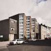
Site Name Burntisland, 75-79 High Street
Classification Shop (19th Century), Tenement (19th Century)
Alternative Name(s) 10-30 (Old Numbering)
Canmore ID 52852
Site Number NT28NW 72
NGR NT 23139 85815
Datum OSGB36 - NGR
Permalink http://canmore.org.uk/site/52852


- Council Fife
- Parish Burntisland
- Former Region Fife
- Former District Kirkcaldy
- Former County Fife
Field Visit (22 May 1928)
Houses, Burntisland.
(a) [NT28NW 71] No. 35 High Street, a three-storeyed house, is built of harled rubble, with a pantiled roof. It presents twin gables to the street. The pediment of the first floor window of the western gable bears the figures 16, while the decade and year, 26, are given on the corresponding pediment on the other gable. The western pediment also contains the initials R.R. set on either side of a shield bearing: Within a bordure, a chevron cheeky between three water-bougets, for Ross. The eastern pediment bears on an oval cartouche, flanked by the initials A.M., the wife's arms; Within a bordure, a saltire between a mullet in chief and three roundels in flanks and base.
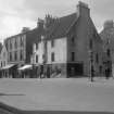
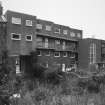
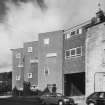
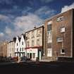
(b) [NT28NW 72] The tenement of three storeys and a garret which stands at the corner of Lothian Street and High Street dates from the 17th century, but has been considerably modernised. The walls are stuccoed and the roof is pantiled. At first-floor level a turret-stair is corbelled out on the south. The upper part of the turret has been removed.
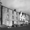
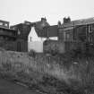
(c) [NT28NW 67] The tenement at the corner of Harbour Place, though much altered, is the only survivor of a picturesque group of 17th-century houses which formerly stood here.
(d) In Somerville Street the outer wall of the modern meeting-place of a Masonic Lodge [NT28NW 69] bears a 17th-century panel inscribed: BLISST BE GOD / FOR AL HIS / VAGE[I]S. The tenement immediately to the west, a three-storeyed harled house, dates from the 17th century, while farther east is No. 20 Somerville Street, also a three storeyed harled house of the 17th century, with some good corbelling of late type on the front. The entrance at the head of the forestair has a later pediment containing a thistle-slip with the initials and date I.A. S.A. 1720, and the quatrain: O LORD THOV ME DEFEND FROM SVB /TILE SORTS OF THOSE THAT FRIEND/SHIP ME PRETENDSAND ARE MY MORTAL FOES.
RCAHMS 1933, visited 22 May 1928.

