
Pricing Change
New pricing for orders of material from this site will come into place shortly. Charges for supply of digital images, digitisation on demand, prints and licensing will be altered.
Forth Defences, Outer, Kinghorn And Pettycur Batteries, Abden Defences


Blockhouse (First World War), Machine Gun Post(S) (First World War), Military Camp (First World War), Trench(S) (First World War)
Site Name Forth Defences, Outer, Kinghorn And Pettycur Batteries, Abden Defences
Classification Blockhouse (First World War), Machine Gun Post(S) (First World War), Military Camp (First World War), Trench(S) (First World War)
Alternative Name(s) Grange Cottages
Canmore ID 52775
Site Number NT28NE 9
NGR NT 26899 88087
NGR Description From NT 25740 87906 to NT 27430 87515
Datum OSGB36 - NGR
Permalink http://canmore.org.uk/site/52775


- Council Fife
- Parish Kinghorn
- Former Region Fife
- Former District Kirkcaldy
- Former County Fife
NT28NE 9 NT 26899 88087
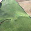
(NT 2692 8808) Circular shadow-mark
Visible on RAF air photographs F21/58/RAF/1712: 0115-16.
Situated on the top of a hill 500m south of Grange at a height of 250ft square there is a vague oval enclosure much reduced by cultivation. It comprises a vague ditch, approx. 2.5m in width and 0.2m in depth, enclosing an area 27.0m N-S by 20.0m E-W. A vague mound is the southern part of the enclosure may, according to the farmer be rock near the surface.
Visited by OS (A C) 18 March 1959.
Project (March 2013 - September 2013)
A project to characterise the quantity and quality of the Scottish resource of known surviving remains of the First World War. Carried out in partnership between Historic Scotland and RCAHMS.
Change Of Classification (3 September 2013)
Recorded previously as an enclosure. This appears to be on the site of a trench system (No.1 Redoubt (Abden)), part of an extensive series of trenches guarding the Kinghorn and Pettycur batteries (see NT28NE 47 and 48) and forming the SE end of a series of defences running NW to Lochgelly.
Information from RCAHMS (AKK) 4 September 2013.
Note (4 September 2013)
A series of 15 trenches, one blockhouse (NT 2671 8800), two machine gun posts and barbed wire entanglement extend across the high ground to the N and E of Kinghorn. The SE end beside the main Kinghorn and Kirkcaldy road is heavily entrenched. The defences to the NW are more sparse and appear to link up with the defences around and south of Lochgelly.
Accommodation for the troops was in a military camp on the E side of the main Kinghorn to Kirkcaldy road, just to the SSE of Abden Farm. Abden farm buildings (see NT28NE 163) were also used by the defending forces.
Three picket shelters (NT28NE 208, 209, 210) were constructed on the approach to the defences as well as a blockhouse (pillbox) by the main railway line (see NT28NE 206).
The defences are shown on a War Office map (The National Archives WO 78/4396).
Information from RCAHMS (AKK) 4 September 2013.

