
Edinburgh, Easter Craiglockhart Hill


Park (Period Unassigned)
Site Name Edinburgh, Easter Craiglockhart Hill
Classification Park (Period Unassigned)
Canmore ID 52710
Site Number NT27SW 81
NGR NT 232 705
NGR Description Centred NT 232 705
Datum OSGB36 - NGR
Permalink http://canmore.org.uk/site/52710


- Council Edinburgh, City Of
- Parish Edinburgh (Edinburgh, City Of)
- Former Region Lothian
- Former District City Of Edinburgh
- Former County Midlothian
NT27SW 81 centred 232 705
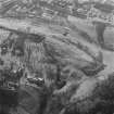
Aerial Photography (1971)
Oblique aerial photographs of Wester Craiglockhart Hill fort, Edinburgh and Easter Craiglockhart Hill, by Mr John Dewar in 1971.
Trial Trench (25 April 2016 - 26 April 2016)
Centred on NT 2340 7060: Archaeological evaluation at Craighouse, Craighouse Road, Edinburgh. Five trenches were opened over two days to investigate a large sample area of the proposed development site (figure 2). Four of the five trenches opened contained no archaeological features. Trench 12, which was excavated in the wooded area to the north of New Craig, contained the remains of a Victorian rubbish pit, with layers of ash presumably from the nearby boiler house. A number of post-medieval finds were recovered from contexts within this trench, which was recorded to a maximum safe depth of 1.2m before natural was encountered at approximately 2m.
Information from Ruby Neale (Wardell Armstrong Archaeology) May 2016. OASIS ID: wardella2-250011

