Accessibility

Font Size

100% 150% 200%

Background Colour

Default Contrast
Close Reset

Edinburgh, Niddrie Mains Road, Niddrie Marischal

Housing Estate (Modern)

Site Name Edinburgh, Niddrie Mains Road, Niddrie Marischal

Classification Housing Estate (Modern)

Alternative Name(s) Edinburgh Niddrie Development; Niddrie House Grove; Tweedsmuir House; Niddrie Mains Pavillion

Canmore ID 52496

Site Number NT27SE 448

NGR NT 299 710

NGR Description Centred NT 299 710

Datum OSGB36 - NGR

Permalink http://canmore.org.uk/site/52496

Ordnance Survey licence number AC0000807262. All rights reserved.
Canmore Disclaimer. © Bluesky International Limited 2025. Public Sector Viewing Terms

Toggle Aerial | View on large map

Digital Images

Elevated view from south showing site of Gasworks, New Street, Edinburgh, with tenements at 181-223 Canongate and modern housing in Old Tolbooth Wynd visible.
Elevated view from south showing site of Gasworks, New Street, Edinburgh, with tenements at 181-223 Canongate and modern housing in Old Tolbooth Wynd visible.Edinburgh, Niddrie Marischal housing estate.
Aerial view of the estate.Edinburgh, Niddrie Marischal Development, Teviotbank & Tweedsmuir House.
View of tower block from South.Edinburgh, Niddrie Marischal Development, Niddrie House Gardens.
Niddrie House Gardens from the South-West.Edinburgh, Niddrie Marischal Development, Niddrie House Drive.
Niddrie House Drive from the South-West.Edinburgh, Niddrie Marischal Development, Niddrie House Grove,
Niddrie House Grove, view from West.Edinburgh, Niddrie Marischal Development, Teviotbank House.
View of tower block from West.Edinburgh, Niddrie Marischal Development, Tweedsmuir House.
View of tower block from West.Edinburgh, Niddrie Marischal housing estate.
General aerial view of housing estate.Niddrie Marischal Development.
Greendykes Gardens, view of rear from South WestEdinburgh, Niddrie Marischal housing estate.
General aerial view of the housing estateEdinburgh, Niddrie Mains Road, Niddrie Marischal, NT27SE 448, Ordnance Survey index card, Recto

Administrative Areas

  • Council Edinburgh, City Of
  • Parish Edinburgh (Edinburgh, City Of)
  • Former Region Lothian
  • Former District City Of Edinburgh
  • Former County Midlothian

Archaeology Notes

NT27SE 448 centred 299 710

Activities

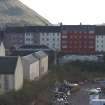
Partial Demolition (8 September 1991)

Tweedsmuire and Teviotbank, two tower blocks built as part of the Niddrie House development project, were demolished eight hours after the first attempt failed.

References

MyCanmore Image Contributions


Contribute an Image

MyCanmore Text Contributions