
Following the launch of trove.scot in February 2025 we are now planning the retiral of some of our webservices. Canmore will be switched off on 24th June 2025. Information about the closure can be found on the HES website: Retiral of HES web services | Historic Environment Scotland
Edinburgh, Canongate, Water Gate


Gateway (16th Century)(Possible)
Site Name Edinburgh, Canongate, Water Gate
Classification Gateway (16th Century)(Possible)
Alternative Name(s) Water Yett
Canmore ID 52462
Site Number NT27SE 414
NGR NT 26747 73944
Datum OSGB36 - NGR
Permalink http://canmore.org.uk/site/52462


- Council Edinburgh, City Of
- Parish Edinburgh (Edinburgh, City Of)
- Former Region Lothian
- Former District City Of Edinburgh
- Former County Midlothian
NT27SE 414 267 739
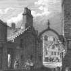
Lying adjacent to the White Horse Close, Water Yett was the principal approach to Canongate from the east coast. Indicated on the town plan of 1544, the Water Yett received notice in 1568 when 'the port and yett pass and into the Abbaye Kirk' were to be refurbished in timber and iron work. When the port or yett was removed is not exactly known although a single arch of wood marked the site until it was blown down in a gale in 1822. It must have served a purely administrative function, perhaps in connection with the collection of tolls.
Maitland Club Extracts 1840; J Grant 1882; D Wilson; A T Simpson, S Stevenson and N Holmes 1981.

