 |
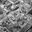
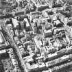
On-line Digital Images |
SC 1679533 |
RCAHMS Aerial Photography |
Aerial view showing High Street between North Bridge and Lawnmarket with Cockburn Street at bottom of photo, City Chambers in centre and St Giles' Cathedral at top |
1990 |
Item Level |
|
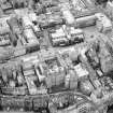 |
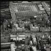
On-line Digital Images |
SC 1679534 |
RCAHMS Aerial Photography |
Aerial view showing High Street between North Bridge and Lawnmarket with Cockburn Street at bottom of photo, City Chambers in centre and St Giles' Cathedral at top. |
1990 |
Item Level |
|
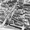 |
On-line Digital Images |
SC 1679757 |
RCAHMS Aerial Photography |
Aerial view showing High Street between North Bridge (on left of photo) and Lawnmarket with St Giles' Cathedral on far right of photo, City Chambers at centre right and Cockburn Street at bottom. |
1983 |
Item Level |
|
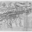 |
On-line Digital Images |
SC 1762312 |
General Collection |
The Plan of the City and Castle of Edinburgh 1742 |
1742 |
Item Level |
|
 |
On-line Digital Images |
SC 1762579 |
General Collection |
Edinburgh, The Mound.
Photographic copy of ground plan showing the Mound, High Street and Lawnmarket.
Titled: 'First Part of Ground Plan'. |
c. 1834 |
Item Level |
|
 |
On-line Digital Images |
SC 1780060 |
RCAHMS Aerial Photography |
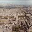
Edinburgh, Old Town.
Aerial view of centre of Edinburgh including Princes Street and New Town at top of photograph, Waverley Bridge to right, Greyfriars and Candlemaker Row at bottom and Castle Esplanade to left |
1985 |
Item Level |
|
 |
On-line Digital Images |
DP 306088 |
City of Edinburgh Council Architectural Drawings and Photographs |
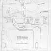
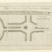
Engraving showing Plan of North and South Bridges showing proposed alterations
Architect James Craig Dated (Published) 1785 |
1785 |
Item Level |
|
 |
On-line Digital Images |
DP 306087 |
City of Edinburgh Council Architectural Drawings and Photographs |
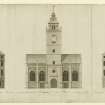
Engraving showing Elevation looking Southward of Tron Kirk and proposed building on Royal Mile
Architect James Craig Dated (Published) 24 July 1786
Dedicated to Rt Hon Sir James Hunter Blair |
24/7/1786 |
Item Level |
|
 |
On-line Digital Images |
SC 1860647 |
RCAHMS Aerial Photography |
Oblique aerial view showing area surrounding Cowgate, including Chambers Street to left of photograph, George IV Bridge at top, High Street to right, and South Bridge to bottom |
1989 |
Item Level |
|
 |
On-line Digital Images |
SC 2443475 |
Records of the Ordnance Survey, Southampton, Hampshire, England |
Edinburgh, High Street, North Bridge To Lawnmarket, General, NT27SE 229, Ordnance Survey index card, Recto |
c. 1958 |
Item Level |
|
 |
On-line Digital Images |
SC 2649383 |
RCAHMS Aerial Photography |
Aerial view showing High Street between North Bridge and Lawnmarket, with St Giles' Cathedral in foreground, City Chambers in centre and Waverley Station at top. |
1990 |
Item Level |
|
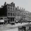 |
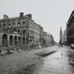
On-line Digital Images |
SC 2649418 |
Papers of Ebenezer J MacRae, architect, Edinburgh, Scotland |
View from south of High Street between North Bridge and Lawnmarket |
c. 1900 |
Item Level |
|
 |
On-line Digital Images |
SC 2649464 |
|
General view of Lawn Market looking towards Camera Obscura. |
|
Item Level |
|
 |
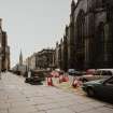
On-line Digital Images |
SC 2649475 |
Records of the Royal Commission on the Ancient and Historical Monuments of Scotland (RCAHMS), Edinbu |
High Street (next to Advocates' Close), view from West |
6/3/1994 |
Item Level |
|
 |
On-line Digital Images |
SC 2649476 |
Records of the Royal Commission on the Ancient and Historical Monuments of Scotland (RCAHMS), Edinbu |
High Street (next to Advocates' Close), view from West |
6/3/1994 |
Item Level |
|
 |
On-line Digital Images |
SC 2649478 |
Records of the Royal Commission on the Ancient and Historical Monuments of Scotland (RCAHMS), Edinbu |
View from East looking towards Tron Kirk and up High Street |
11/5/1995 |
Item Level |
|
 |
On-line Digital Images |
SC 2649479 |
Records of the Royal Commission on the Ancient and Historical Monuments of Scotland (RCAHMS), Edinbu |
View from East looking towards Tron Kirk and up High Street |
11/5/1995 |
Item Level |
|
 |
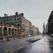
On-line Digital Images |
SC 2649480 |
Records of the Royal Commission on the Ancient and Historical Monuments of Scotland (RCAHMS), Edinbu |
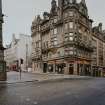
View from South East looking towards junction of North Bridge and High Street |
11/5/1995 |
Item Level |
|
 |
On-line Digital Images |
SC 2649483 |
Records of the Royal Commission on the Ancient and Historical Monuments of Scotland (RCAHMS), Edinbu |
View from South East looking towards junction of North Bridge and High Street |
11/5/1995 |
Item Level |
|
 |
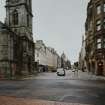
On-line Digital Images |
SC 2649484 |
Records of the Royal Commission on the Ancient and Historical Monuments of Scotland (RCAHMS), Edinbu |
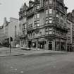
View from East looking towards City Chambers and St. Giles' and up High Street |
11/5/1995 |
Item Level |
|
 |
On-line Digital Images |
SC 2649485 |
Records of the Royal Commission on the Ancient and Historical Monuments of Scotland (RCAHMS), Edinbu |
View from East looking towards City Chambers and St. Giles' and up High Street |
11/5/1995 |
Item Level |
|
 |
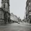
On-line Digital Images |
SC 2649486 |
Records of the Royal Commission on the Ancient and Historical Monuments of Scotland (RCAHMS), Edinbu |
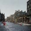
View from West looking towards City Chambers and down High Street |
11/5/1995 |
Item Level |
|
 |
On-line Digital Images |
SC 2649487 |
Records of the Royal Commission on the Ancient and Historical Monuments of Scotland (RCAHMS), Edinbu |
View from West looking towards City Chambers and down High Street |
11/5/1995 |
Item Level |
|
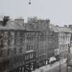 |
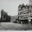
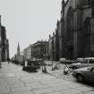
On-line Digital Images |
SC 2649794 |
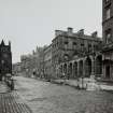
Collection of photographs by George Chrystal and Francis Maxwell Chrystal, photographers, Edinburgh, |
General view of North side of High Street between North Bridge and Lawnmarket |
c. 1900 |
Item Level |
|


