
Edinburgh, Collegiate Church Of St Mary In The Fields


Church (13th Century), Hospital (Medieval)
Site Name Edinburgh, Collegiate Church Of St Mary In The Fields
Classification Church (13th Century), Hospital (Medieval)
Canmore ID 52223
Site Number NT27SE 20
NGR NT 25930 73330
Datum OSGB36 - NGR
Permalink http://canmore.org.uk/site/52223


- Council Edinburgh, City Of
- Parish Edinburgh (Edinburgh, City Of)
- Former Region Lothian
- Former District City Of Edinburgh
- Former County Midlothian
NT27SE 20 2599 7333.
Collegiate Church of St Mary in the Fields (NR) (Site of)
OS 1/500 plan, (1895)
Existed in 1499 when James IV of Scotland obtained seed from its gardens.
W F Gray 1925; C A Malcolm 1925; Old Edinburgh Club 1928; H M Anderson 1935.
Collegiate Church of St Mary in the Fields: Library and adjoining area of quadrangle of the University cover the position of the church. From early sketches, it appears as a low cruciform building of the 13th century, with west tower. The church belonged to Holyrood Abbey and is on record in c.1275. It was granted collegiate rank before 1511 with a provest, ten prebendaries and two choristers. Its hospital was burned by the English in 1544 and about 1552, the Duke of Chatelherault built a mansion on its site, which later became the library of the old University, and was demolished in 1798...(RCAHMS 1951).
H Arnot 1788; M E C Walcott 1874; H F Kerr 1932; RCAHMS 1951.
(NT 2599 7333) Site as described as above, now occupied by University library.
Visited by OS (J D) 25 December 1953.
Publication Account (1951)
72. Collegiate Church of St. Mary in the Fields.
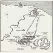
The “Kirk O’ Field” stood within its precinct on part of the site now occupied by the University buildings [NT27SE 357]. The Library and the adjoining area of the quadrangle cover the position of the church, to the E. of which, backing on what is now the W. side of South Bridge, lay the yards and lodgings associated with it; and at the junction of that street with South College Street stood the “Old Provost's House”, where Darnley was murdered in 1567. In the view of Edinburgh of 1544 ([RCAHMS 1951] Fig. 59) the church is shown with a central tower, but the particulars cannot be relied on as the building is drawn conventionally. The church is also represented in a contemporary drawing prepared to illustrate the Darnley murder and now preserved in the Public Record Office, London; but although this drawing was evidently compiled from two sketches made from different viewpoints, and consequently requires some interpretation (1), the particulars of the church are sufficiently clear. It appears as a low cruciform building of the 13th century having a W. tower capped with a saddle-back roof; but the original E. end has been replaced in the 15th century by a lofty choir with the polygonal apse that was current at that time. With the exception of the tower all parts of the church are roofless; nevertheless, it may be assumed that the later choir was vaulted but that the original part of the fabric was not.
The church belonged to Holyrood Abbey and is on record in Bagimond's Roll of c. 1275 (2). In the early 15th century the growth of the Cowgate gave it further importance, and it was granted collegiate rank before 1511* with a provost, ten prebendaries and two choristers.
On the site of its hospital, which had been burned by the English in 1544, the Duke of Chatelherault built a mansion about 1552 (3). This house, which was noteworthy for its gardens and its painted windows, later became the library of the Old University [NT27SE 357], and was only demolished in 1798.
RCAHMS 1951
(1) Cf. Mahon, The Tragedy of Kirk O' Field, passim and P.S.A.S., lxvi (1911-2), pp. 140 ff. (2) Priory of Coldingham, Surtees Society, addenda p. cxii. (3) Accts. L.H.T., x, pp. xxiii f.
*The exact date cannot be stated as the volume of the Calendar of the Papal Registers covering the years 1500 to 1510 has not yet been published.
Publication Account (1981)
St.Mary's-in-the-Fields, located to the south of the Old Town, first appears on record in the late thirteenth century and is shown in a 1544 engraving to have been a large cruciform church with a tall tower in the centre. It was granted collegiate status in the early sixteenth century (Cowan and Easson, 1976, 220), but the prebendaries and nearby hospital were reputedly destroyed by the English in the 1570s. Kirk-0 1 Field was the scene of the murder of Lord Darnley the second husband of Mary, Queen of Scots.
Information from ‘Historic Edinburgh, Canongate and Leith: The Archaeological Implications of Development’ (1981).
Excavation (29 March 2010 - 22 October 2010)
NT 25990 73360 A desk-based assessment and evaluation was undertaken in relation to proposed resurfacing of the Old College Quadrangle courtyard. The desk-based assessment summarised the history of the site and established the approximate position of any possible surviving archaeological remains. The evaluation was carried out 29–31 March 2010 and targeted areas where remains of previous buildings were to be expected. Nine trenches were opened across the interior courtyard amounting to just under 7% of the development area. The trenches confirmed that the ground level in the courtyard had been substantially lowered and levelled c1832 as part of William Playfair’s completion of the existing quadrangle building. A post-medieval stone-lined drain that was encountered is part of Playfair’s building works. Despite the 19th-century down-cutting of the courtyard area, parts of a pre-existing paved surface and wall footings were identified in the NW corner of the site. A small quantity of disarticulated human bone was recovered from an area of redeposited subsoil in the S-central part of the site. This was probably residual from the medieval graveyard of the church of St Mary’s in the Field that had formerly occupied much of the Quadrangle area.
Subsequent monitoring during the general reduction of the court surface identified numerous archaeological features of varying date and led to a more extensive mitigation exercise. Over 84 days from 29 June to 22 October 2010 the entire court surface was cleaned, with numerous individual sondages and wider excavation areas opened up to target and investigate particular areas, features and deposits. The excavation recorded evidence for the substantial landscaping and down-cutting undertaken by Playfair c1832. A broad band of exposed bedrock was recorded across the SW part of the site, bordered to N and E by undisturbed natural subsoils. Playfair’s landscaping activity had eradicated any remains of the medieval church. However, remnants of its associated cemetery were recovered (some quantity of charnel in redeposited material over much of the central part of the site). Where the historic ground surface sloped down further to the N and E a zone of in situ inhumations survived. Down-cutting had been so extensive that these lay just below the modern courtyard surface; of these a total of 44 were disinterred and at least 15 which lay at a deeper level were left undisturbed. There appears to have been four phases of burial, as indicated by both stratigraphy and notable general alignment changes. All ages from neonate to adult of both sexes were represented, suggesting a general population. One triple burial included an adult male, a female and a juvenile.
At least two probable cases of syphilis were identified at the final phase, suggesting a dating of c1500 or thereafter. Evidence was recovered for the use of shrouds (pins, lace, loops, etc); associated ceramics and a late 15th-century coin confirmed a general medieval date. The cemetery appeared to have been bounded by sections of walling identified along its N and E sides. In the SE sector early clay-bonded footings and apparent robber-trenching may relate to ancillary buildings associated with the medieval collegiate church.
The N side of the cemetery was bounded by a lane, partly terraced into the downward sloping ground and formed of multiple episodes of metalling. This lane was bounded by a further wall on its N side and aligned at a slight angle to the subsequent general axes of buildings established on site by the 17th century. Bounding the lane further to the NW and respecting its alignment were the remains of a substantially built masonry structure of apparent later medieval date. Whether this represented parts of a documented infirmary of the medieval collegiate foundation or Hamilton House, the town residence of the Duke of Chatelherault and dating to the early 1550s, was not determined. To the E there survived parts of a massively built kitchen fireplace (including the springing of its arch and well preserved scorched hearthstones) and a truncated slop-sink in the S wall. The latter had evidently fed in to a stone-lined drain that was recorded along the S exterior wall foot. The SW angle of the structure revealed the base of a projecting stair tower. An entrance at the foot of the turnpike evidently led to lower chambers, possibly cellars.
Hamilton House and other existing buildings were incorporated into the new college foundation, later the University of Edinburgh, established by the city in 1582–3. The church was demolished and a large quarry pit on part of its site probably provided building stone for the new works. Remains of a number of 17th-century college buildings were recorded. A vaulted cellar inserted into Hamilton House probably dates to this time. A Quadrangle was formed to the NW – the Laigh College. The remains of the SE corner of this were revealed within the excavation area, including parts of a court surface formed by setts and part of a masonry stair rising to the main court area, the High College to the S. The High Court was bonded on its E side by a major masonry range erected in 1617 and used variously as a library, museum and Common Hall. Parts of the E, S and all of the W walls of this structure were revealed, the latter retaining the preserved dressed threshold stones of its principal entrance. A large sondage at its SW internal angle revealed the beam settings for a wooden floor. Fallen plasterwork recovered from this area formed a substantial ceiling cornice of 17th-century character.
The 1617 building was bonded on its W side by a sunken courtyard; this was fully excavated as part of a voluntary exercise involving students from Edinburgh University. The court had been terraced into upward sloping ground to the W, cutting into the pre-existing cemetery area and retained by a masonry court wall that was punctuated by a masonry stair. The cobbled court surface was exceptionally well preserved and retained a central drainage gully set at a right angle and drawing to the N.
The footprint of a subsidiary building extending W from the S part of the 1617 library building and closing off the S side of the sunken courtyard was recorded. This structure, of 18th-century date, contained a larger chamber to the W with a fireplace in its W wall and a stair chamber to the E. The wooden stair rose up within the semi-circular walling to the S. A secondary entrance at the NW corner of the main room opened into a small building occupying the SW angle of the sunken court; within this survived well preserved remains of a wooden floor.
The N side of the High Court was bounded by a library range erected in 1642–6. Its S wall was recorded in a number of sondages, which showed that this cut through the pre-existing metalled lane along much of its length. Its SW corner had been built around the SE angle of Hamilton House. Fragments of court paving were recorded along the S side of Hamilton House. The early buildings revealed in the excavations were demolished between c1790, when Robert Adam commenced construction of the existing college buildings, and c1825 when his scheme was continued using a revised design by William Playfair. The lower parts of the early buildings and sunken courtyard were infilled with their own demolition rubble.
The remains of assorted chemical compounds including arsenic and mercury and fragments of glassware were recovered from the W end of the interior of the 1642 library and are considered to represent the contents of an early 19th-century chemistry laboratory. Further remains of later date included the foundations of stairs set at 45° into each of the corners of the Quad. These were part of the initial Playfair scheme and survived until the mid-20th century alongside a fountain base in the W end of the Quad. An extensive network of stone-lined drains related principally to the Playfair period.
Archive: RCAHMS
Funder: The University of Edinburgh
Ross Cameron, Tom Addyman, Tanja Romankiewicz, Cath Richards and Kenneth Macfadyen – Addyman Archaeology/Simpson and Brown Architects
OASIS ID - addymana1-102603
Project (1 March 2010 - 25 November 2011)
Addyman Archaeology was commissioned by The University of Edinburgh to undertake archaeological work in response to the planning application to develop the grounds of Old College Quadrangle in Edinburgh.
Old College is built on the site of the medieval church and hospital of St Mary -in-the-Fields (NT27SE 20) and Hamilton House. The area became infamous as the site of the murder of Lord Darnley in February 1567. The Kirk O'Fields was granted to the newly founded (1582) University of Edinburgh. It is not known when the church and hospital buildings were demolished but Hamilton House (NT27SE 6136), which had become the Universtiy library, was demolished in 1798.
Information from Addyman Archaeology, 2010
Excavation (14 June 2011 - 30 June 2011)
NT 25990 73360 A programme of archaeological investigation was undertaken in the Old College Quadrangle for the University of Edinburgh in 2010 (DES 2010, 67–69). This work included a large scale excavation that revealed the vestigial remains of the historic Kirk o’ Fields, the associated cemetery and the buildings of the early University of Edinburgh. Excavation within the cellar area of the library building along the N side of the existing quad, constructed in 1642–6, revealed a small quantity of brightly coloured compounds and fragments of glass apparatus. Subsequent assessment of the materials showed them to be highly toxic and the glass to be in the nature of chemistry apparatus. Health and Safety concerns dictated this area remain undisturbed.
Subsequent assessment of the recovered materials during the post-excavation process identified a reference which indicated the chemistry apparatus of renowned scholar of the Scottish Enlightenment, the chemist Professor Joseph Black, was stored in the basement of the library building after his death in 1799 (and perhaps considerably earlier, from c1780). Assessment of the glass and ceramic artefacts by Dr Robert Anderson indicated these objects to be of outstanding significance in the history and development of early chemistry. This discovery was deemed especially important as 2011 is the International Year of Chemistry. It was therefore agreed by the University of Edinburgh to reopen the trench in this area to recover a more representative sample and this work was undertaken 14–30 June 2011.
Removal of the demolition rubble from within the SW angle of the cellar of the 1642 building, an area of 5 x 2.5m, revealed a spread of artefacts of exceptional variety and significance. These artefacts all lay directly atop the beaten floor surface of the building, and seemed to represent a combination of debris accumulated during the building’s use and materials abandoned when the range was ultimately demolished in 1820.
A wide variety of artefacts was recovered and recorded. The artefacts were predominantly of glass and ceramic with a notable number of metal objects; also apparent were concentrations of chemical compounds of a variety of colours. Many of the ceramic vessels also retained or contained apparent chemical residues. A large number of glass rods were recovered, some solid and some evidently thermometer sections, as well as fragments of what appear to be test tubes. Of particular note was a quantity of small ceramic crucibles.
Apparently immediately predating the deposition of the chemistry materials was the find of some 40 pieces of founders type, used in the printing process. Documentary sources indicate that from 1754 the college’s Press was situated in this chamber, referred to by one source as ‘the printing house immediately under the [Low Library]’ – run by the College Printer, Hamilton and Balfour. An earth-fast setting of four post-pipes located within the excavation area may relate to the former position of a press.
A deeper sondage at one point identified an apparent wall trench set at the same alignment as some of the 16th-century and earlier structures identified within the 2010 excavations. The excavation was necessarily undertaken under a strict Health and Safety regime.
Archive: RCAHMS
Funder: University of Edinburgh
Ross Cameron and Tom Addyman – Addyman Archaeology/Simpson and Brown Architects 2011 OASIS ID - addymana1-102603

