
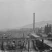
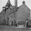
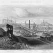
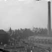
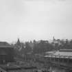
Edinburgh, New Street, Gasworks


Gas Works (19th Century)
Site Name Edinburgh, New Street, Gasworks
Classification Gas Works (19th Century)
Alternative Name(s) Canongate Gasworks
Canmore ID 52212
Site Number NT27SE 190
NGR NT 26295 73848
Datum OSGB36 - NGR
Permalink http://canmore.org.uk/site/52212


- Council Edinburgh, City Of
- Parish Edinburgh (Edinburgh, City Of)
- Former Region Lothian
- Former District City Of Edinburgh
- Former County Midlothian
NT27SE 190 263 738
NT27SE 190.01 Furnaces, Garage, Workshops
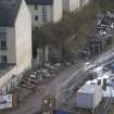
Watching Brief (1999)
NT 2636 7375 An archaeological watching brief was conducted in support of engineering site investigation works at the site of a former gasworks on Calton Road. Six test pits were monitored and made ground varied from 0.5m to in excess of 3m. All made ground appeared to be predominantly composed of 19th-century foundations, demolition material and cellarage.
Sponsor: Barratts East of Scotland.
R McCullagh and J Gooder 1999
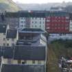
Archaeological Evaluation (2000)
NT 2636 7377 An archaeological evaluation was carried out on a 4ha parcel of land adjacent to Calton Road and Old Tolbooth Wynd. The two northernmost trenches contained a buried cultivation soil, up to 2m thick, containing ceramic artefacts dating between the 12th and 18th centuries, situated at some depth below modern 'made ground'. In the other five trenches, 'made ground' and recent building foundations directly overlay or truncated natural subsoil.
Sponsor: Barratt East Scotland.
J Gooder 2000.

