
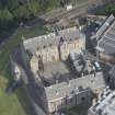
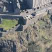
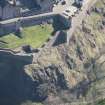
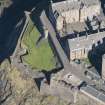
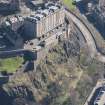
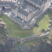
Edinburgh Castle, Sally Port And Guard House


Gateway (18th Century), Outbuilding (18th Century)
Site Name Edinburgh Castle, Sally Port And Guard House
Classification Gateway (18th Century), Outbuilding (18th Century)
Canmore ID 52079
Site Number NT27SE 1.19
NGR NT 25007 73532
Datum OSGB36 - NGR
Permalink http://canmore.org.uk/site/52079


- Council Edinburgh, City Of
- Parish Edinburgh (Edinburgh, City Of)
- Former Region Lothian
- Former District City Of Edinburgh
- Former County Midlothian
NT27SE 1.19 25007 73532
Sally Port and Guard House (NR) (Site of).
OS 1/1250 plan.
(NT 2501 7353). No remarks. No information contained in RCAHMS 1951. Visited by OS(JLD) 29 December 1953.
No further information
Visited by OS(SFS) 10 November 1975.
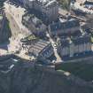
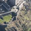
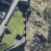
NT 250 735 Three small test pits were excavated, and the previously excavated sallyport guardhouse was re-examined, all located within the area of the western defences, as preparation for opening up this part of the castle to the public. Three test pits were all placed at the foot of flights of steps, in an attempt to find out if more stairs had ever existed. Both of the flights of steps examined which were parallel to the parapet wall did produce evidence for a robbed-out stair, while the base of the flight of three steps out of the sentry box did not.
Sponsor: Historic Scotland
D Murray 1999
Excavation (26 April 1999 - 28 April 1999)
Kirkdale Archaeology were asked to excavate three small test pits, and clean up the previously excavated Sallyport Guardhouse, all located within the area of the Western Defences (NT 250 735, Fig. 1), as preparation for opening up this part of the castle to the public.
The primary aim of the exercise, the examination the base of the stairs to look for further steps, was successful. Both of the flights of steps examined which were parallel to the parapet wall did produce evidence for a robbed-out stair, while the base of the flight of three steps out of the sentry box did not. Additionally the loose infill deposits ((104), (202) and (302)) could be seen in Test Pits 1 and 2 to predate the steps (represented by (102) and (301)), while in Test Pit 2, (202) had built up against the steps (203). If these contexts can indeed be equated, then this makes the steps out of the sentry box earlier than the steps of the parapet walkway; possibly they have been replaced at some point, as presumably stairs have existed ever since the construction of the wall. The date of this infilling is uncertain, the rather mixed finds assemblage only supporting the idea that this must postdate the walls’ construction in the 1730's. Although the level of the steps out of the sentry box, which are presumably contemporary with the walls’ construction, relates to the modern ground level, they may have connected to a walkway carried on the wallhead, without the great build-up of soil on the inside of the wall. It should be noted that terracing upslope (to the E) of the defences is not shown on the 1877 OS map, so the landscaping of this area may have taken place quite late in the castle's history. The implication of this great depth of infill is that there is the possibility of the survival of early deposits sealed beneath this.
Sponsor: Historic Scotland
D Murray 1999
Kirkdale Archaeology

