
Pricing Change
New pricing for orders of material from this site will come into place shortly. Charges for supply of digital images, digitisation on demand, prints and licensing will be altered.
Edinburgh, Granton, West Shore Road, Granton Castle, Dovecot And Boundary Wall


Dovecot (17th Century), Wall (17th Century)
Site Name Edinburgh, Granton, West Shore Road, Granton Castle, Dovecot And Boundary Wall
Classification Dovecot (17th Century), Wall (17th Century)
Alternative Name(s) Granton House
Canmore ID 52037
Site Number NT27NW 15
NGR NT 22601 77223
Datum OSGB36 - NGR
Permalink http://canmore.org.uk/site/52037


- Council Edinburgh, City Of
- Parish Edinburgh (Edinburgh, City Of)
- Former Region Lothian
- Former District City Of Edinburgh
- Former County Midlothian
NT27NW 15 22601 77223
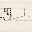
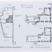
(NT 2260 7722) The dovecot which belonged to Granton Castle is rectangular, 19'6" x 13'11", with 2'8" thick walls, the rear one being c 20' high, and the front 13' There are two broad string courses on all four walls, which are of rubble sandstone, some harling remains on the N wall. There are entrances in the W and the S wall, and in the W wall; an entrance in N wall has been blocked up. Each gable has six crow-steps and the roof is slated. Part of the partition wall which divided the interior into two chambers still remains, but the 880 nest holes have been removed. No entrance holes for pigions can now be seen, and the dovecot is now in use as a store.
A N Robertson 1945; A N Robertson 1949.
No change to previous information.
Visited by OS (B S), 26 November 1975.
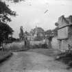
(NT 225 772) A desk-based assessment and walkover survey were carried out in September 2002 on the site of a proposed primary school. This showed that Granton Castle (NT27NW 2) and features of its designed landscape lay within the proposed development area, including a B-Listed doocot and a boundary wall. The area previously occupied by Granton Castle lies within an area of quarrying. There were no visible traces of the castle, but the doocot and boundary walls are still standing and appear to be in good condition.
Report lodged with Edinburgh SMR and the NMRS.
Sponsor: City of Edinburgh Council.
M Johnson 2003.
Watching Brief (6 December 2017 - 31 January 2018)
An archaeological watching brief was carried out at land 120m south of 20 West Shore Road, Granton, Edinburgh during ground-works for the construction of 11 temporary nest houses and a temporary social hub. The development area encompasses the site of the 16th century Granton Castle, which was demolished in the late 1920s and the underlying rock on which it was situated quarried away. The watching brief identified a fragment of wall which appears to relate to a curving feature depicted on the 1914 Ordnance Survey map. There were no features, artefacts or deposits of archaeological significance identified.
Information from Stuart Mitchell and Magnus Kirby (CFA Archaeology Ltd) April 2018. OASIS ID: cfaarcha1-315143
Standing Building Recording (28 October 2022 - 30 November 2022)
NT 22601 77223 GUARD Archaeology Ltd were commissioned to undertake a detailed historic building recording on Granton Walled Garden listed building prior to repair works at Granton, Edinburgh. The work revealed that the Garden walls, boundary walls and Dovecot are most likely post-medieval, dating to the seventeenth century with alterations and extensions occurring during late nineteenth to the late twentieth century.
Information from E Perez-Fernandez - GUARD Archaeology Ltd.
OASIS ID: guardarc1-438575

