
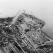
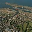
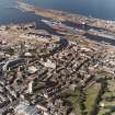
Edinburgh, Leith Docks, Albert Dock


Dock (19th Century)
Site Name Edinburgh, Leith Docks, Albert Dock
Classification Dock (19th Century)
Canmore ID 51988
Site Number NT27NE 57.38
NGR NT 27377 76861
Datum OSGB36 - NGR
Permalink http://canmore.org.uk/site/51988


- Council Edinburgh, City Of
- Parish Edinburgh (Edinburgh, City Of)
- Former Region Lothian
- Former District City Of Edinburgh
- Former County Midlothian
NT27NE 57.38 27377 76861
Formerly entered as NT57NE 63.00.
See also:
NT27NE 57.11 NT 27559 76765 Swing Bridge between Albert Dock and Edinburgh Dock
NT27NE 57.15 NT 27150 76925 Workshops
NT27NE 57.16 NT 27050 77030 Albert Dock Basin
NT27NE 57.18 NT 27147 76863 Prince of Wales Dry Dock
NT27NE 57.19 NT 27134 76935 Prince of Wales Dry Dock. Hydraulic Power Station
NT27NE 57.26 NT 27148 76863 Alexandra Dry Dock
NT27NE 57.39 NT 27230 76959 Hydraulic Crane and Cabin
NT27NE 57.40 NT 27226 76947 Hydraulic Capstan
NT27NE 57.50 NT 27243 76989 Custom House
NT27NE 57.53 NT 27160 76960 Old Entrance Lock
NT27NE 57.56 NT 27525 76860 (Transit) shed at NE corner
NT27NE 57.57 NT 27262 77017 Swing Bridge between Albert Dock and Imperial Dock
NT27NE 57.58 NT 27180 76955 Swing bridge between Albert Dock and Albert Dock Basin
Albert Dock [NAT]
OS 1:1250 map, 1970.
Archaeological Evaluation (20 June 2013 - 25 June 2013)
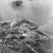
NT 2724 7676 A trial trenching evaluation was carried out, 20–25 June 2013, prior to a proposed residential development on a brownfield site. A total of seven trenches covering 7% (479m2) were excavated across the site. The demolition of the buildings associated with the active use of Albert Docks and the travelling cranes had been extensive and comprehensive. Barring the survival of the actual Albert Docks frontage there only remained a small area of survival in the SW corner of the site. This consisted of areas of cobbling and train tracks, which were cleaned and recorded.
Archive: RCAHMS (intended)
Funder: Cala Homes (East)
Lindsay Dunbar, AOC Archaeology Group, 2013
(Source: DES)

