
Tonga, Scatness


Fort (Period Unassigned)
Site Name Tonga, Scatness
Classification Fort (Period Unassigned)
Alternative Name(s) North Fort; Scat Ness
Canmore ID 518
Site Number HU30NE 5
NGR HU 3889 0879
Datum OSGB36 - NGR
Permalink http://canmore.org.uk/site/518


First 100 images shown. See the Collections panel (below) for a link to all digital images.
- Council Shetland Islands
- Parish Dunrossness
- Former Region Shetland Islands Area
- Former District Shetland
- Former County Shetland
HU30NE 5 3889 0879
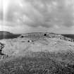
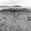
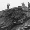
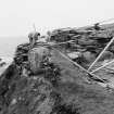
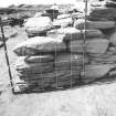
HU 389 088. A fort comprising two ramparts separated by a broad scoop is situated on the E side of Scatness. The outer rampart is a dump, 4ft to 5ft high, running in a curve from edge to edge of the low cliff, so as to enclose a broad headland. This headland is cut off by the inner rampart which is straight, 4ft high and 15ft broad; it is revetted at the front with large blocks.
R G Lamb 1971
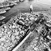
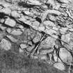
This site, consisting of a blockhouse enclosed by a bank and ditch, was substantially excavated in 1983. The structural evolution of the blockhouse was determined and a small assemblage of pottery and bone was recovered. Radiocarbon dates indicate late use of the site in the first millenium AD but original construction dates could not be determined.
S Carter, R McCullagh and A MacSween 1995.
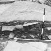
Excavation (1983)
This site, consisting of a blockhouse enclosed by a bank and ditch, was substantially excavated in 1983. The structural evolution of the blockhouse was determined and a small assemblage of pottery and bone was recovered. Radiocarbon dates indicate late use of the site in the first millenium AD but original construction dates could not be determined.
S Carter, R McCullagh and A MacSween 1995.
Publication Account (2002)
HU30 3 SCATNESS
HU 389008
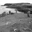
This gatehouse promontory fort stands 400 m north of Ness of Burgi (HU30 2), on another promontory on the same rocky coast. It was first identified as such by Lamb in 1971 [2] and it was clear then that sea erosion on the north side of the promontory was gradually destroying the building. The site is very similar to Ness of Burgi (HU30 2) and a summary of the results of the excavation sheds light on the former site as well.
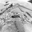
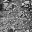
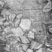
Excavations were undertaken in 1983 [3] and revealed just over half of a massive rectangular dry stone building; the east part, almost up to the central entrance passage, had been destroyed.
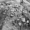
The primary structure (Phase 1): The gatehouse was built an behind outer defence which cut off the small promontory. Excavations could reveal no stratigraphical connection between the two features so it has to be assumed that the wide, curved bank with internal ditch is part of the primary site [3, Ill. 2]. A section across these features revealed that the bank was a simple dumped structure which survives up to 0.7 m high. The rock-cut ditch was 7.3 m wide and 1.7 m deep at the point trenched and lay immediately within the bank, with no intervening berm. The highly unusual pattern of this outer defence, having an internal ditch, is not explicable at present; such arrangements are usually thought to be for ceremonial rather than defensive sites, as with Neolithic henge monuments.
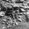
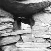
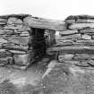
The entrance passage of the gatehouse is 4.0m long and 1.2 m wide at its outer end; The highest surviving masonry was the west passage wall which at one point stood 1.6m high. At a distance of 1.3 m in from the front end is the door frame, the checks being composed of long thin stone slabs let into the passage walls at right angles. A bar-hole was found in the west side just inside the door frame but the east wall was too low for the socket to be preserved. Inwards from the door the passage was 1.5 m wide; no lintels were found in position or lying on the floor.
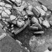
The building was 4.0 m wide in its original form and must have been some 15.5m along its central axis since the surviving west part is 7.0m in length and the passage is 1.5 m wide. A large, oblong or trapezoidal mural cell -- presumably originally constructed with a corbelled roof -- is in the west part. The cell measured c. 4.0 m long by 1.8 m wide and was reached by an narrow passage at its east end, parallel with the main entrance and emerging in the rear wall close to it. This had two lintels still in position and measured 1.05 m high and only 50 cm wide. One interesting structural feature noted was a void or stress-relieving opening above this passage [3, Ill. 6]; though this is something which is characteristic of brochs such a device is presumably likely to have been devised wherever stress has to be removed from the lintels of a passage in a high wall.
A small narrow cell, with its long axis at right angles to that of the large one, was found at the extreme west end of the structure; the only access into it was by way of a rectangular opening 40 cm high by 20 cm and 40 cm above the floor. There were clear signs that this cell had a corbelled roof. One has the impression that this might have been a dungeon.
No artefacts or datable carbon were found associated with the Phase 1 features.
Secondary features (Phase 2);: the gatehouse was eventually modified with added masonry which rested on the same ground surface as the primary features; there does not therefore appear to have been an interval of abandonment between Phases 1 and 2 unless the debris of this was cleared away before the later features were built.
Secondary dry stone masonry was built against both the rear (south) wall -- increasing the thickness of the gatehouse by 1.8 m the whole way along. The entrance passage was lengthened by this, as was the narrow passage leading to the mural cell; the existence of a second large cell in the vanished east half seems to be confirmed by the fact that a passage was left between the original building and the added masonry to the east of the main entrance; this is only likely to have led to such a cell.
The west cell was contracted by blocks of similar masonry at either and by a thinner wall along its south side. All these additions were presumably made at about the same time.
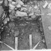
Phase 3: considerable quantities of material gradually accumulated, up to a thickness of 40 cm, both within the east cell, against the secondary south face of the block-house, against its primary north face and in the main entrance passage [3, Ill. 5]. Radiocarbon dates were obtained from this material indicating activity in the middle or latter part of the 1st millennium AD. Some plain pottery, presumably of the late Iron Age, was recovered from these deposits [3, Ill. 9].
There seems to be no way of knowing whether the Phase 1 gatehouse was still intact at this time -- in other words whether the passage and the mural cells were still roofed and the wall was standing to its original height -- or whether it was a reduced structure with roofless intra-mural features the debris of which had been removed from the site. The fact that no lintels from the entrance passage were found in the debris of the final collapse (below) suggests the latter.
Phase 4: rubble on top of these deposits marked the final collapse of the gatehouse into an uninhabited ruin; in certain places like the entrance passage this collapse evidently took place in distinct stages. No artefacts or datable material were recovered.
Sources: 1. OS card no. HU30 SE 21: 2. Lamb 1980: 3. Carter, McCullagh and MacSween 1996, 430-45.
E W MacKie 2002
The RCAHMS number for this site is HU30NE 5.
Information from RCAHMS (LMcC) 17 July 2009
Note (1 March 2016 - 10 November 2016)
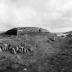
The remains of a blockhouse standing behind a broad ditch with an external rampart on a minor promontory on the E shore of the West Voe of Sumburgh 400m N of Ness of Burgi (Atlas No.4180), was excavated in 1983 (Carter et al 1995) in advance of ongoing marine erosion, which by then had destroyed E half of the structure. The surviving W half, which measured at least 9m in length from E to W by 4m in breadth, and had a doorway in its S wall lead into an axial chamber to which a smaller chamber at the W end was linked by an opening measuring no more than 0.4m by 0.2m. Both sides of what was presumably a central entrance passage survived on the edge of the cliff on the E and retained checks and a bar-hole. At a later stage the whole blockhouse had been extensively rebuilt and the southern wall thickened, hiding what were probably stone steps up its outside wall at the W end, and all the deposits excavated within the interior dated from after this modification. The relationship between the blockhouse and the outlying ditch with its external rampart could not be established stratigraphically, and while it is assumed to be associated, the blockhouse lies eccentrically within the enclosed area. This currently measures about 30m in depth from N to S by 15m in breadth (0.03ha), but the arc of the ditch, which is over 7m broad and 1.7m deep where sectioned, springs from the cliff-edge immediately W of the blockhouse and swings on a wide, ragged, arc some 14m to the N, ending 9m short of a geo on the NE to leave what was presumably an entrance causeway. Thus configured, the promontory must have measured at least 25m in breadth, and the blockhouse was positioned across the middle of the interior, with as much ground in front of it as behind. No trace of any other structures were found on the surviving portion of the promontory, though ten deposits of charcoal and ash interpreted as fire-spots were excavated, two of them dated 6th-10th centuries AD, as was another sample of charcoal from the entrance passage into the W chamber; these probably relate to a post-abandonment phase before the walls began to collapse and provide no more than a terminus ante quem for the construction, use and modification of the blockhouse.
Information from An Atlas of Hillforts of Great Britain and Ireland – 10 November 2016. Atlas of Hillforts SC4181

