Pricing Change
New pricing for orders of material from this site will come into place shortly. Charges for supply of digital images, digitisation on demand, prints and licensing will be altered.
Mavisbank House, Dovecot
Dovecot (18th Century)
Site Name Mavisbank House, Dovecot
Classification Dovecot (18th Century)
Alternative Name(s) Doo'cot; New Saughton Hall; Mavisbank House Policies
Canmore ID 51713
Site Number NT26NE 54.06
NGR NT 29392 65742
Datum OSGB36 - NGR
Permalink http://canmore.org.uk/site/51713
- Council Midlothian
- Parish Lasswade
- Former Region Lothian
- Former District Midlothian
- Former County Midlothian
NT 28807 65146 (Mavisbank House) A re-assessment was undertaken of the designed landscape and analytical history of Mavisbank House. Compilation of a gazetteer of landscape features and built structures represents a comprehensive upgrading of previous assessments.
A previously unrecorded ice house was discovered below the existing game larder; well preserved and linked to the game larder. A possible 'tump' or stand of trees forming a visual terminus to the northern vista was also identified.
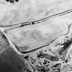
Assessment was undertaken of the doocot forming the 'eye-catcher' at the E end of the main vista. Low walls on either side had been reduced in height; patchings on either side of the doocot tower suggested that these walls had been shaped in order to form a silhouette on the skyline as seen from the house.
Initial assessment of the walled garden confirmed that this had originally been oval, but designed so that it appeared circular when viewed from the house. It was deduced that there had been a further vista aligned on the centre of the S frontage of the house that bisected the walled garden.
The SW annexe to the walled garden, now triangular in form, had most probably been rectangular originally, as suggested by Roy's map of c 1750. The surviving gazebo was deduced to have been on the central axis of this former arrangement, an axis that may also have been aligned on the doocot at the E end of the policies.
Archive to be deposited in the NMRS.
T Addyman 2004
NT26NE 54.06 29392 65742
(NT 2938 6574) Dovecot (NAT)
OS 6" map (1938)
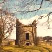
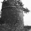
This cylindrical dovecot was probably adapted from an old tower. The roof, missing, must have been a ridge one as the walls rise east and west with a round curve to become lower in front and behind (N and S); where the rise begins, on each side, is a skewput. It has no nests.
A N Robertson 1957
This tower is generally as described. It has two doors, one above the other on its S side while high up on the E is a small, barred, circular window. There are portions of walling on the E and W sides showing that it has been built into the boundary well. No trace of nesting boxes could be found and it is more likely to have been a watch tower. (It is listed by the SDD as a (?) 18th century dovecot).
Visited by OS (SFS) 23 October 1975
NMRS REFERENCE:
Built 1738 as terminal point of a vista up through hedges to the top of a hill.
EXTERNAL REFERENCE:
Scottish Records Office - Penicuik Papers - information on layout of garden
Tall, circular doocot. Upper third partially missing; roofless. Random sandstone rubble with ashlar dressings to doorways. String course at two thirds height; oculus with cill course below to SE face; cill course with no opening to NW face opposite; sunken doorway with relieving arch to SW face with full doorway and relieving arch set above.
No evidence of nesting boxes remains. The building certainly formed an integral part of the designed landscape around Mavisbank. From the house ran three radial avenues and a canal, the central axis terminated by this circular eye-catcher doocot to the NE of the house. The oculus reflects similar features in the pediment and pavilion wings of the main house and the former Jointure House on Linden Place, Loanhead (see separate list entries). A-group with Mavisbank House, Doocot, Gazebo, Walled Gardens, Ice House, Game Larder and East Lodge (Kevock Road, Lasswade). (Historic Environment Scotland)


