
Following the launch of trove.scot in February 2025 we are now planning the retiral of some of our webservices. Canmore will be switched off on 24th June 2025. Information about the closure can be found on the HES website: Retiral of HES web services | Historic Environment Scotland
Penicuik, St Kentigern's Church And Churchyard


Burial Ground (Post Medieval), Church (17th Century), Churchyard (Post Medieval)
Site Name Penicuik, St Kentigern's Church And Churchyard
Classification Burial Ground (Post Medieval), Church (17th Century), Churchyard (Post Medieval)
Alternative Name(s) Old Parish Church; Penicuik Kirk
Canmore ID 51652
Site Number NT25NW 9
NGR NT 23708 59984
Datum OSGB36 - NGR
Permalink http://canmore.org.uk/site/51652


- Council Midlothian
- Parish Penicuik (Midlothian)
- Former Region Lothian
- Former District Midlothian
- Former County Midlothian
NT25NW 9.00 23708 59984
(NT 23708 59984) Church (NR) (In Ruins)
OS 6" map (1932)
Ch (NAT)
OS 6" map (1957)
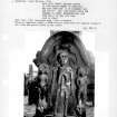
NT25NW 9.01 NT 23735 59989 Clerks of Penicuik Mausoleum (St Mungo's Church)
A list of improvements made by Sir John Clerk of Penicuik shows 'The great Isle of Penicuik Kirk over against the pulpit, for the use of my tenants and the steeple from the ground, both on my own charges.' The list starts from 1714 without specifying the year of each item, but the MS of a scheme for improving the barony as a whole was completed in 1741. The tower therefore should be dated between 1714 and 1741. The church should be called by the more familiar title of St Mungo rather than the formal St Kentigern.
J Gray 1895
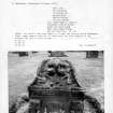
At Kentigern's (RCAHMS 1929) or St Mungo's (H Scott 1915) Church: The ruins of the former parish church stands within the churchyard of the 18th c church still in use, and are of a post-Reformation structure, probably single-chambered and oblong in plan. Only portions of the wall remain and are incorporated in a burial enclosure, but the tower is still intact. This is a 17th c structure, rubble-built, and three storeys in height, and has a hipped timber- built and slated roof. At ground floor level is a simple vaulted chamber with an entrance in the W wall. External dimensions are 13'2" N-S and 12'7" E-W. The floor above has openings in the E, S, and W walls, that in the E wall communicating with a gallery built against the W gable of the church. The top storey has a bell-chamber, and in each wall is a window with a semicircular head.
E of the ruins of the church is the 17th c mausoleum of the clerks of Penicuik. It bears an inscription with the date 1684, and is 14 1/4' square.
H Scott 1915; RCAHMS 1929, visited 1920.
The remains of the tower and contiguous burial enclosure are as described above. A built-up window and doorway of indeterminate date are visible in the S wall of the enclosure.
The mausoleum is in very good condition and is attached by a short passage to a burial enclosure to the W, which appears to have been built on old wall footings, possibly the E end of the church.
Visited by OS (DT) 5 December 1962
The remains of this church are as described by previous authorities. The tower has been recently renovated.
Visited by OS (BS) 4 November 1975
NMRS REFERENCE
Contract for building a burial vault.
Agreements between Sir John Clerk and masons in Pennycook.
Design included.
1685 GD 18/1752

