
Following the launch of trove.scot in February 2025 we are now planning the retiral of some of our webservices. Canmore will be switched off on 24th June 2025. Information about the closure can be found on the HES website: Retiral of HES web services | Historic Environment Scotland
Brunston


Rig And Furrow (Medieval) - (Post Medieval)
Site Name Brunston
Classification Rig And Furrow (Medieval) - (Post Medieval)
Canmore ID 51640
Site Number NT25NW 28
NGR NT 2013 5791
Datum OSGB36 - NGR
Permalink http://canmore.org.uk/site/51640


- Council Midlothian
- Parish Penicuik (Midlothian)
- Former Region Lothian
- Former District Midlothian
- Former County Midlothian
NT25NW 28 201 578.
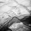
This site has previously been classified as a possible fort. The impression of ramparts has been gained from a small block of ridge and furrow lying along the slope creating at least two pronounced terraces.
Information from RCAHMS (DCC) 30 October 2006
Field Visit (2 December 2019 - 24 February 2020)
(NT 20154 57897) Desk-Based Assessment - This site has previously been classified as a possible fort. The impression of ramparts has been gained from a small block of rig and furrow lying along the slope creating at least two pronounced terraces (Information from RCAHMS (DCC) 30 October 2006). Recorded on aerial imagery from 1982 and 2001.
Walkover survey - Rig block that forms two distinct semi-circular ridges with steep slopes to the NW down to North River Esk. In total, the area is approximately 20m wide (NW-SE) by 100m (NE-SW). Each bank/rig is approximately 6m wide with the internal furrow/ditch approximately 3m. The area to the S and SE is boggy and there is possibly an area of rough grass/pasture that may be associated with rig and furrow; possible smaller undulations that are ephemeral traces of rig & furrow (not mapped).
Information from OASIS Id: rathmell1-387946 (P Klemen and T Rees) 2020

