
Pricing Change
New pricing for orders of material from this site will come into place shortly. Charges for supply of digital images, digitisation on demand, prints and licensing will be altered.
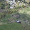
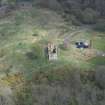
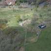
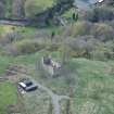
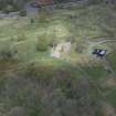
Penicuik, Castle Brae, Uttershill Castle


Tower House (Medieval)
Site Name Penicuik, Castle Brae, Uttershill Castle
Classification Tower House (Medieval)
Alternative Name(s) Utters Hill; Outtershill Castle
Canmore ID 51621
Site Number NT25NW 10
NGR NT 23849 59430
Datum OSGB36 - NGR
Permalink http://canmore.org.uk/site/51621


- Council Midlothian
- Parish Penicuik (Midlothian)
- Former Region Lothian
- Former District Midlothian
- Former County Midlothian
NT25NW 10 23849 59430
(NY 23849 59430) Uttershill Castle (NR)
(Remains of)
OS 6" map (1957)
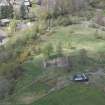
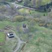
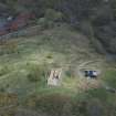
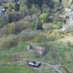
Outters Hill Castle: the ruin of a late 16th century mansion, built of freestone rubble once probably harled. It is oblong in plan, measuring externally 65' NE-SW by 23', and has been at least three storeys high, two of which are still standing. An outbuilding once stood against the eastern porton of the S wall, but has long since been removed.
RCAHMS 1929, visited 1920
The remains of Uttershill Castle are generally as described and planned except that the internal wall has disappeared and only the springing of the vaulting remains. The castle stands on a low platform bounded to the NE by a scarp about 0.8m high with uncertain traces continuing along the NW side.
Revised at 25".
Visited by OS (DT), 6 December 1962
Previous field report confirmed.
Visited by OS (BS) 4 November 1975
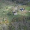
NT 23849 59430. Excavation was carried out in September - October 1994 at Uttershill Castle, in advance of a proposed restoration programme. The interior of the castle was emptied of all deposits down to 300mm below the original floor level, and additional trenches were excavated immediately outside the S wall (fig.25).
The excavations revealed a complex structural sequence, confirming information gathered from a documentary study by Mr N Q Bogdan. The castle appears initially to have been a two-storied bastle house c.12m long by 7m wide externally, with a vaulted undercroft incoporating a central drain, built in the late 16th century. Its upper part was modified in the early 17th century before being extended to the E. This extension had a kitchen on the ground floor with a solar above, and made the castle c.19.8m long externally. An integral part of this construction was a previously unknown structure c.4.1m long and at least 1.7m wide, built against the southern side of the extension. The remains of another structure, c.2.7m wide and c.2.9m long, were found abutted against the southern side of the western end of the castle and this structure may also have been constructed in the 17th century.
After the castle was abandoned, the roof gables, and external structures collapsed and were probably robbed, leaving the box-like remains visible at present. These remains then appear to have been cleared of rubble, removing most in situ archaeological deposits, and the castle was used as a gunpowder store. In addition, the remains were allegedly subjected to an early 20th century excavation which was not published. The survival of archaeological deposits within the castle was consequently limited. However, trenches excavated outside the castle have provided more late material suggesting that despite severe tree root disturbance further in situ deposits may survive here.
Sponsor: Mr J Grounsell
D Alexander (CFA).

