
Pricing Change
New pricing for orders of material from this site will come into place shortly. Charges for supply of digital images, digitisation on demand, prints and licensing will be altered.
Black Meldon


Settlement(S) (Period Unassigned)
Site Name Black Meldon
Classification Settlement(S) (Period Unassigned)
Canmore ID 51527
Site Number NT24SW 11
NGR NT 2120 4255
Datum OSGB36 - NGR
Permalink http://canmore.org.uk/site/51527


- Council Scottish Borders, The
- Parish Peebles
- Former Region Borders
- Former District Tweeddale
- Former County Peebles-shire
NT24SW 11 2120 4255.
(NT 2120 4255) Enclosure (NR)
OS 6" map (1965)
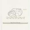
The heavily robbed remains of a settlement, and of a scooped homestead which superseded it, are situated near the foot of the E slopes of Black Meldon. The settlement (A on plan) is considerably obscured by the scooped homestead which has obliterated almost the whole of its S end, and more recent disturbance has been caused by a track which passes through it from N-S. Enough remains, however, to indicate that it measured originally c.155' N-S by 80' E-W within a boulder-faced rubble wall. Only a few of the facing stones of this wall are now visible, and what remains of the core has spread to form a low grassy mound. The entrance is near the centre of the E side; it is now 11' wide and leads into a small shallow depression. Three house platforms (1-3) are visible in the remaining part of the interior. At the N end a low stony bank running W from the NE arc of the enclosing wall is clearly intrusive. The scooped homestead (B) measures 75' x 50' within a boulder-faced rubble wall in which several outer facing stones are visible. The entrance, in the centre of the E side, is 6' wide and leads into a scooped court occupying 2/3 of the lower half of the interior. The upper half contains three house-platforms (4-6) separated by unexcavated ridges.
RCAHMS 1967, visited 1964
A settlement and homestead as described.
Revised at 1/2500.
Visited by OS (JLD) 8 May 1962 and (BS) 23 September 1974
Photographed by the RCAHMS in 1980.
Sbc Note
Visibility: This is an upstanding earthwork or monument.
Information from Scottish Borders Council

