
Pricing Change
New pricing for orders of material from this site will come into place shortly. Charges for supply of digital images, digitisation on demand, prints and licensing will be altered.
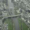
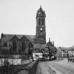
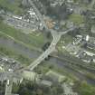
Peebles, High Street, Parish Church


Church (19th Century), Font (Period Unassigned)(Possible), War Memorial (20th Century)
Site Name Peebles, High Street, Parish Church
Classification Church (19th Century), Font (Period Unassigned)(Possible), War Memorial (20th Century)
Alternative Name(s) Old Parish Church
Canmore ID 51509
Site Number NT24SE 69
NGR NT 25011 40392
Datum OSGB36 - NGR
Permalink http://canmore.org.uk/site/51509


- Council Scottish Borders, The
- Parish Peebles
- Former Region Borders
- Former District Tweeddale
- Former County Peebles-shire
Photographic Record (1896)
Photograph album with views from the Scottish Borders in 1896 including Peebles
Publication Account (1977)
Prior to the Reformation the church in the 'Old Town' dedicated to St. Andrews served as the parish church for Peebles. It existed at least as early as the first quarter of the twelfth century (Lawrie, 1905, 46). Little is known of its original fabric or condition. Foundations have occasionally been discovered through gravedigging and it has been suggested that the church had two aisles, one on the north side of the choir and another on the north side of the nave and that it was larger in size than the later dedication, the Cross Kirk (Gunn, 1908, 201). It suffered extensive damage in 1549 when it was burned by the English and the tot al repair bill was too great for the parishioners to meet. In 1560 the townsmen were granted use of the Cross Kirk and the church of St. Andrews slowly fell into ruin. Some attempt was made to preserve what fabric and burial ground remained in use, but there was much quarrying and in 1609 a 'dowcot' was built in the church steeple (Williamson, 1895, 10). Tradition maintains that Cromwell stabled his horses in the church during his siege of Neidpath Castle, but this incident is not recorded in the burgh records (Renwick, 1910, xxi). In 1856 the structure consisted of a few broken walls and a massive tower (Chambers, 1856, 51) and the tower was 'drastically' restored in the second half of the nineteenth century (RCAHM,1967, 210).
A path connected St. Andrews Church with the later dedication, the Cross Kirk, also in the 'Old Town'. The Cross Kirk was established by Alexander ill after the 1261 discovery of holy relics on the site, including a cross and the ashes of bones allegedly belonging to 'St. Nicholas the Bishop' (Cowan and Easson, 1976, 109). At first, Cross Kirk was non-conventual and the only building on the site was the church, an aisleless rectangle. A community of Trinitarian friars appears to have been established there with the approval of the bailies by 1448 (Cowan, 1976, 110) and in 1474 the domestic buildings and cloisters were erected to the north of the church (RCAHM, 1967, 204). In January 1560-1, the Trinitarians quit their convent and the Cross Kirk was fitted up as a Protestant place of worship. Despite the change in religious order, the Cross Kirk remained a haunt for pilgrims at least until 1601, when a notice appears that in the year following 'there was no resorting of people into the Croce Kirk to commit any sign of superstition there' (Gunn, 1912, 67). The Cross Kirk served as the parish church until 1784. In the middle of the sixteenth century a western tower was added and alterations to the building in the seventeenth century included the construction of a new parish church on the Castlehill the roof of the Cross Kirk was removed but the walls were kept entire and in 1809 an application was made to turn the church into a coal fold, although this plan was ultimately abandoned (Chambers, 1856, 53) . Chambers relates that as late as 18ll the foundations of the cloisters were still visible but they were eventually cleared away when the ground was enclosed and planted (1856, 53). In that same year part of the south wall of the church collapsed (RCAHM, 1967, 204).
The Town Council of Peebles in 1773 agreed to contribute towards the building of a new parish church on the Castlehill and gave the necessary ground between the High Street and the bowling green (Buchan, 1925, ii, llO). Chambers caustically observed that the church stood 'awkwardly awry to the direction of the public street, the fabric generally and the steeple in particular bear the unmistakable marks of the dearth of taste which pervaded during the reign of George ill' (1856, 55). The present parish church on this site dates from the late nineteenth century.
Information from ‘Historic Peebles: The Archaeological Implications of Development’ (1977).
Watching Brief (13 April 2010 - 15 April 2010)
NT 25049 40406
A watching brief carried out 13–15 April 2010, during the construction of an access ramp, recorded a number of archaeological features. The removal of ivy and scrub revealed the remnants of two walls; associated cobbled floors and two further walls were subsequently recorded during the excavation of foundation pits. The features appear to relate to industrial buildings depicted on the 1865 OS large
scale town plan of Peebles.
Archive: RCAHMS (intended)
Funder: Forestry Civil Engineering
A Hunter-Blair 2010
Sbc Note
Visibility: This is an upstanding building.
Information from Scottish Borders Council.
Sbc Note
A WWII siren was found in the steeple of Peebles Parish Church during conservation. Was used as an air-raid siren then as a signal for the fire brigade until 1979.
Information from Scottish Borders Council Historic Environment Record
(n.d.)

