
Pricing Change
New pricing for orders of material from this site will come into place shortly. Charges for supply of digital images, digitisation on demand, prints and licensing will be altered.
Peebles, Castle Hill, Castle


Castle (Medieval)
Site Name Peebles, Castle Hill, Castle
Classification Castle (Medieval)
Alternative Name(s) Peebles Castle
Canmore ID 51452
Site Number NT24SE 17
NGR NT 2502 4038
Datum OSGB36 - NGR
Permalink http://canmore.org.uk/site/51452


- Council Scottish Borders, The
- Parish Peebles
- Former Region Borders
- Former District Tweeddale
- Former County Peebles-shire
NT24SE 17 2502 4038.
(NT 2502 4038) Site of Peebles Castle (NR)
OS 25" map (1856)
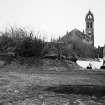
There was a royal castle at Peebles in the reign of David I (1124-53). High Street runs directly to the site of the castle, believed to be a motte which occupied the neck of a promontory formed by the junction of the Eddleston Water with the River Tweed. The site is marked by a prominent, steep-sided mound, apparently natural, which has Peebles parish church on its E end. The flat summit measures 70ft by 130ft, though it may originally have been longer. There are no visible structural remains. Excavations were carried out in 1977 by the DoE in advance of the building of an extension to the church hall; a report is not yet available. When a new prison and county rooms were erected in 1841, immediately N of the church, some of the foundations of the castle are said to have been found. Sherds of medieval pottery from the summit of the mound were donated to the National Museum of Antiquities of Scotland (NMAS) in 1961-2.
It is probable that the castle was destroyed during the Wars of Independence, for in 1334 when Edward Baliol granted several towns, castles and counties of the Borders to Edward III, only the 'town and county of Peebles' were mentioned, not its castle. Also, from 1327 there ceased to be any mention of the grant of ten shillings annually made to the Chapel of the Castle of Peebles. The Castlehill appears to have come into the town's possession in the 15th century.
SBS Peebles 1977; RCAHMS 1967, visited 1964; Proc Soc Antiq Scot 1964
No further information.
Visited by OS (EGC) 27 February 1962
Publication Account (1977)
There was a royal castle at Peebles in the reign of David I (Barrow, 1960, 24). High Street runs directly to the site of the castle, believed to be a motte, placed strategically at the confluence of the River Tweed and Eddleston Water. It was a situation of considerable strength.
It is probable that the castle was destroyed during the Wars of Independence, for in 1334 when Edward Baliol, self-styled King of Scots, granted several towns, castles and counties of the Borders to Edward m, including Roxburgh, Berwick-upon-Tweed and Dumfries, only the 'town and county of Peebles' was mentioned, not its castle (CDS, iii, co. ll27). Also, from 1327 there ceased to be any mention of the grant often shillings annually made to the Chapel of the Castle of Peebles (Gunn, 1908, 50). In the fifteenth century the Castlehill seems to have come into the town's possession and there appear to have been some buildings in its neighbourhood. The mill and other erections on the south side of the Castlehill were expressly confirmed to the town by a 1508 charter (Renwick, 1903 (b), 22).
In 1720 trees were planted around the base of the hill and a site was laid out for a bowling green (Chambers, 1864, 262). Chambers made the claim that Peebles castle was still in existence by the late seventeenth century (1864, 262). This confusion grew out of an entry in the Earl of Tweeddale's Rental Book 1671-1685 in which 'Peebles Castle' is mentioned, but it was simply another name for the nearby tower house, Neidpath Castle (Renwick, 1912, 89).
Information from ‘Historic Peebles: The Archaeological Implications of Development’ (1977).
External Reference (5 December 2014)
This monument was excluded from the schedule of monuments compiled and maintained under section 1(1) of the Ancient Monuments and Archaeological Areas Act 1979.
Information from Historic Scotland, 5th December 2014
Sbc Note
Visibility: This site has been excavated.
Information from Scottish Borders Council

