
Moat Knowe


Moot Hill (Period Unassigned)(Possible)
Site Name Moat Knowe
Classification Moot Hill (Period Unassigned)(Possible)
Canmore ID 51432
Site Number NT24NW 39
NGR NT 2360 4720
Datum OSGB36 - NGR
Permalink http://canmore.org.uk/site/51432


- Council Scottish Borders, The
- Parish Eddleston
- Former Region Borders
- Former District Tweeddale
- Former County Peebles-shire
NT24NW 39 2360 4720
Moat Knowe (NAT)
OS 6" map (1966)
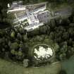
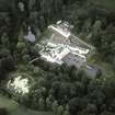
Though Neilson asserts that there is a motte at Darnhall (NT24NW 18), the RCAHMS describe Moat Knowe as a flat-topped conical knowe. Standing as it does in a slight bay in a steep rise, the knoll has the appearance of having originally been a promontory which was severed at a remote period of time by the action of water, It may have been trimmed artificially to its present regular shape, possibly by landscape gardeners, but the near presence of ground of equal height would have rendered it useless as a motte. The Moat Knowe is traditionally the place "where the Murrays used to dispense justice in olden days".
RCAHMS 1967, visited 1959; E S Armitage 1912; G Neilson 1898
This is undoubtedly landscaping.
Visited by OS (DWR) 24 April 1971.
Sbc Note
Visibility: This is an upstanding earthwork or monument.
Information from Scottish Borders Council

