Glenrath Hope
Field System(S) (Period Unassigned), Settlement(S) (Period Unassigned)
Site Name Glenrath Hope
Classification Field System(S) (Period Unassigned), Settlement(S) (Period Unassigned)
Canmore ID 51363
Site Number NT23SW 21
NGR NT 222 326
NGR Description From NT 213 328 to NT 228 323
Datum OSGB36 - NGR
Permalink http://canmore.org.uk/site/51363
- Council Scottish Borders, The
- Parish Manor
- Former Region Borders
- Former District Tweeddale
- Former County Peebles-shire
NT23SW 21 213 328 - 228 323.
(Name NT 2232 3252) Village (NR) (Site of)
OS 6" map (1965)
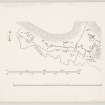
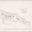
Between the lower slopes of the hills bordering Glenrath Hope on the N and the right banks of the Glenrath Burn and its tributary the Back Burn, there is an expanse of gently sloping ground, one mile in length and some 35 acres in extent, on which the remains of settlements and an associated field-system are visible. Originally these may have been extended beyond Glenrath Hope into the Manor Valley, but if so all traces of their presence there have been obliterated by subsequent cultivation.
The settlements, which lie immediately below the steep scree-covered slopes and above the cultivated ground, do not conform to any set pattern, but are simply agglomerations of circular houses, together with small enclosures or courts.
The settlement (A) comprises three courts (A, B, C) the rear, or NE parts of which have been buried by scree falling from the hill-side above. The courts are bounded by walls which now appear as bands of rubble about 6 ft wide. Court A which is entered from the S communicates directly through a gap in a mutual wall with court B. A house (1) measuring internally 18 ft in diameter, and with its entrance opening into court A, is incorporated in the W arc of the court wall. Likewise, a second house (2) measuring internally 20 ft in diameter, is incorporated in the mutual wall between courts B and C ad opens into the latter. A smaller circular foundation (3) measuring internally some 8 ft in diameter is bounded into the S angle of the wall of court C a few feet SE of the entrance. Another house-foundation (4), measuring internally 20 ft in diameter, lies in the NW part of court C; the position of its entrance is not now apparent. A short stretch of ruined wall leads off north-westwards from the W sector of the wall of court C, while the foundations of an oval structure of uncertain date, measuring axially 16 ft by 8 ft lie a few yards to the SW of court B.
Excavations (R B K Stevenson 1941) carried out in B revealed a stone- walled house, measuring internally 14 ft in diameter, which was bounded into the court wall. The only find was an ornamental spindle whorl.
The field-system associated with the settlements is formed partly by stony banks, most of which run down the gentle slope towards the burns, and partly by lynchets often with ruined walls along their crests, which lie roughly parallel to the contours.
Considerable numbers of clearance cairns occur in the fields and along the banks, while the foundations of a few isolated circular houses, apparently similar to those in the settlements, are visible in the SE and central parts of the system.
A group of six cultivation terraces measuring about 170 yds in length, has obliterated the earlier system at a point about half way along it, where a belt of conifers has recently been planted.
The field-system and the settlements are probably of Romano British or sub Roman origin, like the comparable examples at Dreva and Stan Hope. Although a few other systems of this kind have been recorded in Scotland this is by far the most extensive, and bears comparison with the best of those in Westmorland and Yorkshire.
RCAHMS 1967, visited 1964
A dense covering of bracken makes precise interpretation of this site difficult. The clearance heaps and field boundary dykes can be distinguished but only three of the many huts shown by RCAHM are positively identifiable.
A. (NT 22363248) A rubble and earth-walled hut measuring 6.5m in internal diameter. The wall is spread to 2.0m in the N half but is completely destroyed elsewhere. There is a possible inner facing stone in the N. The position of the entrance is not clear.
B (NT 22403248) Measures 9.0m in internal diameter within a stony wall which is spread to 2.0m. The wall is best preserved in the NE where several possible inner facing stones can be seen. The entrance is in the SW.
C (NT 22763239) This hut appears as an oval platform 12.0m E-W by 11.0m. On the S is a wall of large stones spread to 2.0m while only faint traces of this wall survive on the N. The interior is stony and grass-covered and there is no apparent entrance.
Revised at 1/10 560.
Visited by OS (WDJ) 28 May 1962 and (BS) 22 October 1974
In the latter part of the description (above) are refernces to three 'huts' A, B and C. Hut A now appears to have been partly excavated as it now clearly has an internal eliptical walled chamber in the NE quardrant measuring 4m NS by 2m. The chamber walls are about 0.6m deep below the exisiting floor level of the surrounding 'hut-circle'. Immediately to the S are four long boulders aligned EW. These possibly could have been removed recently from the chamber (collapsed roof?) Perhaps the description as a hut should be amended - it could have been a cairn with a chamber or a hut with a 'cellar' (I would hesitate to decribe it as a souterrain).
Information contained in a letter to RCAHMS from Mr R S Kidd, Aberdeen, August 1998; NMRS MS 958/11
Publication Account (1985)
Glenrath, the 'valley of the settlement', was formerly the route of an important drove road over to the Douglas Water. The hills around Glenrath are steep with screes, and snow can lie low well into March. For about 1.5km along the northern side of the valley bottom, facing south, are plentiful traces of human settlement-some 14 ha in all. The land is criss-crossed with old dykes, field systems and traces of habitation.
The settlements lie immediately below the screes and above the cultivated ground. They are essentially the ruinous clusters of circular houses, together with small enclosures which do not appear to conform to any set pattern. The most extensive ruins are found east of the plantation; and at 'A' consist of three courts (now partly buried by falling scree), with circular houses up to 6m diameter bonded into their enclosing walls. The only find during excavations at 'B' was a single ornamented spindle whorl.
In association with the settlements is a field system which consists partly of stony banks, presumably once dykes, running down the slope; and partly of lynchets (steep banks below pieces of cultivated ground) often topped with ruinous dykes and running along the contour. There are many clearance cairns (of stones removed from the soil during cultivation) both within the fields and on the banks; there are also a number of isolated, circular structures, apparently similar to those in the settlement and dug very clearly into the slope.
Where reasonably complete fields survive, they were clearly not larger than 0.2 ha-longer than wide in a ratio of 2.5:1. These are the so-called 'Celtic' square fields. Similar, though badly-damaged systems can be identified at Dreva (no. 87) and a fragment at Stanhope (NT 147280)-all of them in narrow locations, with limited areas of cultivable land. At Tamshiel Rig, by contrast, (NT 643062), 'Celtic' long fields are in evidence-much less common in Scotland.
Information from 'Exploring Scotland's Heritage: Lothian and Borders', (1985).
Excavation (11 June 2013 - 24 August 2013)
NT 222 326 A programme of community archaeology was focused on the extensive settlement and field system complex at Glenrath Hope, Manor Valley on 11 June 2013. The project aimed to disentangle the evidence for prehistoric and early historic settlement represented in the upstanding stone roundhouses, field boundaries and enclosures in the valley through detailed topographic survey and targeted excavations of key buildings.
Survey was carried out as a training exercise using a range of techniques including plane table and offset drawing, total station and differential GPS. In addition, a detailed terrain model was constructed using laser scanning. The survey work identified a range of building types and relationships, demonstrating that the field system and structures were clearly of composite, multi-period character. Excavations were carried out at two key buildings; one of the terraced stone-walled roundhouses thought to relate to an early stage in the development of the field system; and at an unusual longhouse structure of very different character to any of the other buildings in the valley.
Excavation of the roundhouse showed the building to be c9m in diameter, with a substantial stone wall terraced into the slope above the field system. The roundhouse wall had been re-lined with a second inner face in the upslope area, and this rebuild sealed a dark occupation deposit. Other deposits in the interior of the building were very thin and contained few artefacts, though a small number of pot sherds and a fragment of a shale or cannel coal bracelet were recovered. A hearth pit was located in the S, downslope area of the roundhouse and was lined with stones, but the interior was otherwise featureless. The entrance to the building was not obvious, but was probably located in the ruinous S area.
The second was a long rectangular building, one of the few demonstrably rectangular buildings in the Glenrath Valley. This building was first identified by Smith (1982; 1990) who suggested that the building may be Norse in origin. Whilst a possibility, it is equally plausible that building could be medieval or post-medieval in date. Excavation revealed that the building, at least in a later phase consisted of two rooms, defined by the remains of an ephemeral stone foundation layer. However, excavation of the walls demonstrated that the building underwent a varied history. It appears that one of the rooms may have been built first, with the second room added on later. At some juncture the S wall was revetted, conjoining the two rooms together. Excavation also revealed that the building sat on top of an agricultural soil which, in turn, overlay other walls and a cairn. Unfortunately, the interior soils were very shallow. Finds were few and initial assessment suggests that none are diagnostic of a particular period. Post-excavation analysis is currently ongoing.
Archive: RCAHMS
Funder: Historic Scotland
Graeme Cavers, Andy Heald, Charlotte Douglas, AOC Archaeology Group, 2013
(Source: DES)
Sbc Note
Visibility: This is an upstanding earthwork or monument.
Information from Scottish Borders Council


