
Kirkburn, Our Lady's Church And Graveyard


Burial Ground (Post Medieval), Church (Post Medieval)
Site Name Kirkburn, Our Lady's Church And Graveyard
Classification Burial Ground (Post Medieval), Church (Post Medieval)
Alternative Name(s) Old Parish Church Of Kailzie
Canmore ID 51276
Site Number NT23NE 8
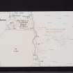
NGR NT 2917 3829
Datum OSGB36 - NGR
Permalink http://canmore.org.uk/site/51276


- Council Scottish Borders, The
- Parish Traquair
- Former Region Borders
- Former District Tweeddale
- Former County Peebles-shire
NT23NE 8 2917 3829.
(NT 2917 3829) Our Lady's Church (NR) (remains of)
OS 6" map (1965)
See also NT23NE 61, Church of Our Lady of Hopekailzie.
Old Parish Church of Kailzie, Kirkburn. The church of Hopekailzie, dedicated to St Mary the Virgin, seems originally to have been a chapel dependent upon Innerleithen. Soon after the middle of the 12th century it passed into the possession of the abbey of Kelso, which retained it until the 16th century. The parish was a small one and, although a new church was evidently erected in 1614, the parish was suppressed in 1674, the greater part of it being annexed to that of Traquair.
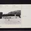
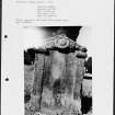
The church stood close to the Kirk Burn, and the site is now occupied by an enclosure which is orientated roughly E and W and measures 69' 6" by 23' 2" over walls having a thickness of 2' 10". This enclosure appears to have been formed for purposes of burial in 1724, but its dimensions and general appearance alike suggest that it incorporates some portions of the church of 1614, which was no doubt abandoned at the suppression of the parish in 1674. The N doorway of the enclosure has a quirked edge- roll and its lintel bears an incised inscription. The lower part of the inscription divides the date 1724. The lintel of the S doorway bears a reversed monogram now so worn as to be illegible. The interior of the enclosure is divided into separate burial-places by partition walls of varying dates, and in the middle of the 19th century the W end of the building, which was then roofed, was reserved for the interment of the Williamsons of Cardrona.
Outside the enclosure there is a graveyard, but it appears to contain no stones of a date earlier than 1707.
RCAHMS 1967, visited 1958
As described. Names confirmed.
Both names are known but Our Lady's Church most commonly used.
Revised at 25".
Visited by OS (RD) 30 April 1971.
NT 290 382 Due to the proximity of the site of Our Lady's Church and graveyard to a proposed development, and the finding of a bronze axe in the same field, a watching brief was undertaken in May 2005 during the excavation of topsoil, prior to the construction of an agricultural shed and associated new access. No significant archaeological features or artefacts were encountered.
Archive to be deposited in NMRS.
Sponsor: Synergy Properties.
R Toolis 2005
External Reference (22 January 2015)
This monument was excluded from the schedule of monuments compiled and maintained under section 1(1) of the Ancient Monuments and Archaeological Areas Act 1979.
Information from Historic Scotland, 22nd January 2015
Sbc Note
Visibility: Upstanding building, which may not be intact.
Information from Scottish Borders Council

