
Horsburgh Castle


Enclosure (Period Unassigned)
Site Name Horsburgh Castle
Classification Enclosure (Period Unassigned)
Canmore ID 51257
Site Number NT23NE 28
NGR NT 2869 3913
Datum OSGB36 - NGR
Permalink http://canmore.org.uk/site/51257


- Council Scottish Borders, The
- Parish Innerleithen
- Former Region Borders
- Former District Tweeddale
- Former County Peebles-shire
NT23NE 28 2869 3913
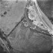
(NT 2869 3913) Cropmark (visible on air photograph DK 23)
[CUCAP] (Undated information in NMRS).
An inconclusive L-shaped cropmark in the corner of a slightly sloping field. Nothing visible on the ground.
Visited by OS (RD), 8 June 1971.
Sbc Note
Visibility: This site is visible as a cropmark.
Information from Scottish Borders Council

