
Eshiels


Temporary Camp(S) (Roman)
Site Name Eshiels
Classification Temporary Camp(S) (Roman)
Canmore ID 51256
Site Number NT23NE 27
NGR NT 28150 39530
NGR Description Centred NT 28150 39530
Datum OSGB36 - NGR
Permalink http://canmore.org.uk/site/51256


- Council Scottish Borders, The
- Parish Peebles
- Former Region Borders
- Former District Tweeddale
- Former County Peebles-shire
NT23NE 27 centred NT 28150 39530
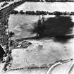
(NT 281 395) The site of two Roman temporary camps has been identified on APs and by probing. The smaller measures 940' x 800', enclosing an area of c. 17 acres. The N and S gates are placed centrally in their respective sides, and are protected in each case by a tutulus, but the positions of the E and W gates have not been found.
The W side of this camp forms part of the W side of a larger camp, of which much of the S side and part of the E side, as well as the rounded SW angle may be traced. It measures 1,050' E-W by just over 1,150', enclosing c. 27 acres. The positions of the gates have not been determined.
No trace of these camps is visible on the ground.
RCAHMS 1967, visited 1963 and 1965
No trace.
Visited by OS (RD) 8 June 1971
Cropmarks on aerial photographs (RCAHMSAP & J Dent, Borders Regional Council Archaeologist, 1992) have revealed further information about the larger of the two camps. Traces of an oblique (Stracathro-type) traverse protecting the E gate is visible, and an earlier photograph taken by CUCAP (AKH 48) suggests the beginning of an oblique traverse on the W side. There are also traces of a clavicula on the S side on aerial photographs (J Dent, Borders Regional Council Archaeologist, 1992) of the field in pasture to the W of the Linn Burn.
Information from RCAHMS (RHM & GSM) 14 February 1996.
Publication Account (17 December 2011)
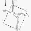
The two camps at Eshiels lie on a level terrace on the north bank of the River Tweed. First recorded through cropmarks from the air in 1962 by St Joseph (1965: 79), the camps share part of their WNW sides. The full extent of camp I, the larger of the two, is not known, but 414m of the ESE side has been recorded, and, on topographic and morphological grounds, it is unlikely to have been much longer. It measures 327m from WNW to ESE, and it is likely that some 13.6ha were enclosed (almost 34 acres). Traces of a Stracathro-type entrance are recorded on its ESE and WNW sides: an oblique traverse is visible on the ESE side and that on the WSW may even have oblique traverses on either side of the gap; there are slight hints of an external clavicula on the south side (not depicted on illus 124).
Camp II, the inner camp, shares part of its WSW side with camp I. It measures 313m from NNE to SSW by 247m and enclosed 7.7ha (19 acres). Entrances in the centre of the NNE and SS W sides are visible, and both are protected by tituli. It is not possible to state whether it utilised the same entrance on the WNW side as camp I, because of the differing form of entrance protection.
RCAHMS probed the site in the early 1960s. It is unclear exactly where the probing took place on the camp, but a combination of probing and air photographs led them to construct much of the circuit of the camp, which by plan and dimensions must be camp II (1967: 171).
R H Jones
External Reference (9 September 2015)
The entry in the Schedule of Monuments relating to this monument was amended in 2015.
Information from Historic Scotland, 9th September 2015
Sbc Note
Visibility: This site is visible as a cropmark.
Information from Scottish Borders Council

