
Horsburgh Castle


Fort (Prehistoric)
Site Name Horsburgh Castle
Classification Fort (Prehistoric)
Canmore ID 51254
Site Number NT23NE 25
NGR NT 2852 3917
Datum OSGB36 - NGR
Permalink http://canmore.org.uk/site/51254


- Council Scottish Borders, The
- Parish Innerleithen
- Former Region Borders
- Former District Tweeddale
- Former County Peebles-shire
NT23NE 25 2852 3917
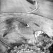
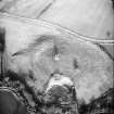
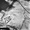
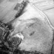
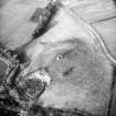
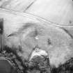
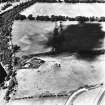
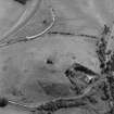
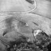
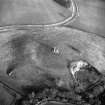
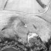
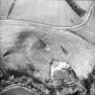
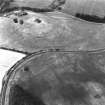
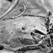
Crop marks on APs (541/A/438:4039-40) reveal the existence of a fort on the summit of the prominent hill that is crowned by Horsburgh Castle (NT23NE 6). Almost circular on plan, it measures about 250' in diameter within double ditches, each of which was presumably accompanied by an internal rampart. No trace of the fort is visible on the surface.
RCAHMS 1967, visited 1961
While the hill referred to would provide a fairly strong position, there is no evidence of a fort on the ground nor is it clear what RCAHMS have seen on APs.
Visited by OS (RD) 7 June 1971
(NT 2852 3917) Fort, Horsburgh Castle, photographed by the RCAHMS in 1976.
Note (16 October 2015 - 18 May 2016)
The site of this fort, which is known only from cropmarks, is marked by Horsburgh Castle (RCAHMS 1967, 236, no.511), a 16th-century tower situated on the summit of a low hill low down on the N side of Tweed valley at the foot of the S spur of Castle Hill. Roughly circular on plan, It measures about 115m in diameter within a ditch about 4m in breadth, and around at least the NE quarter there is also a concentric outer ditch. Allowing for the presence of an inner rampart, the featureless interior is about 0.88ha in extent. No entrances have yet been recorded.
Information from An Atlas of Hillforts of Great Britain and Ireland – 18 May 2016. Atlas of Hillforts SC3645
Sbc Note
Visibility: This site is visible as a cropmark.
Information from Scottish Borders Council
Sbc Note
Supposedly, cropmarks on AP's show the existence of a fort but this is not clear and although it is a strong position there is no evidence on the ground.
Information from Scottish Borders Council

