
Peebles, Haystoun House And Adjoining Courtyard West Range


Country House (16th Century)
Site Name Peebles, Haystoun House And Adjoining Courtyard West Range
Classification Country House (16th Century)
Alternative Name(s) Haystoun House Farm
Canmore ID 51248
Site Number NT23NE 2
NGR NT 25929 38290
Datum OSGB36 - NGR
Permalink http://canmore.org.uk/site/51248


- Council Scottish Borders, The
- Parish Peebles
- Former Region Borders
- Former District Tweeddale
- Former County Peebles-shire
NT23NE 2.00 25929 38290
NT23NE 2.01 25979 38302 Walled Garden
NT23NE 2.02 25953 38306 Courtyard East Range
NT23NE 2.03 2585 3843 Sawmill
(NT 2593 3828) Haystoun (NAT)
OS 6" map (1965)
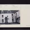
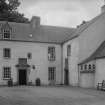
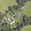
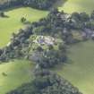
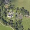
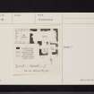
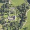
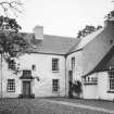
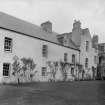
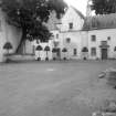
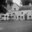
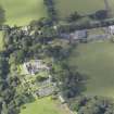
The old mansion-house of the Hays of Haystoun stands with its farm-steading and offices at the mouth of the valley of the Glensax (or Haystoun) Burn. The house is grouped round three sides of a courtyard open to the N. With its trim slated roof, fresh harling and cleanly hewn dressings the building looks homogeneous, but a close examination of the fabric shows that it is of piecemeal construction, embodying work of several periods.
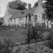
The earliest part of the house occupies the SW corner of the present courtyard and may be ascribed to the late 16th or early 17th century. The original house was extensively remodelled in the late 17th and early 18th centuries, new windows and a new entrance-doorway being inserted, and an eastern extension added to provide kitchen accommodation and extra dwelling-space, while towards the end of the 18th century a new staircase was inserted. Shortly afterwards the building ceased to be the principal residence of the Hays and became in turn a factor's house and a farmhouse, and it was probably at this period that it was extended round three sides of a courtyard by the erection of additional buildings. A final scheme of restoration was completed in about 1920, when the whole building was again remodelled preparatory to its re- occupation by the proprietor as a principal residence.
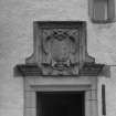
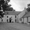
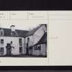
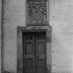
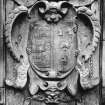
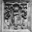
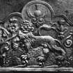
The original house comprises a main block, which runs roughly E-W, together with a N wing. The building may have risen rather higher than its present height of two storeys and an attic, for the wall-heads, where exposed in the attic, show signs of curtailment. Very few original external features remain. Most of the windows have chamfered arrises and evidently date from the late 17th and early 18th century, but some have been remodelled in comparatively recent times. The entrance doorway in the E wall of the wing has a moulded architrave upon which there is incised the date 1730; immediately above the doorway there is an armorial panel bearing the date 1660. The entrance doorway in the N wall of the eastern extension, now the principal entrance to the house, was remodelled during the alterations of c. 1920 when there was incorporated above it an armorial panel bearing the date 1676.
The earliest portion of the house was probably erected during the occupation of the Elphinstone family who held the lands of Haystoun, then called Henderstoun, from at least as early as 1500 until about 1622. In 1635 the estate was ac uired by Andrew Hay, W S, a descendant of the Hays of Smithfield. The Hays continued to reside at Haystoun until after the death in 1810 of Dr James Hay, who some five years earlied had successfully established a claim to the dormant Smithfield baronetcy. The new laird, Sir John Hay of Smithfield and Haystoun, and his successors lived at Kingsmeadows until the present proprietor, Sir Duncan Hay, again took up residence at Haystoun about 1920.
RCAHMS 1967, visited 1961
As described and planned. Name confirmed.
Visited by OS (RD) 7 August 1971
The house and associated garden and sawmill are visible on large scale vertical air photographs (OS 72/274/1004, flown 1972).
Information from RCAHMS
Sbc Note
Visibility: This is an upstanding building.
Information from Scottish Borders Council.

