
Following the launch of trove.scot in February 2025 we are now planning the retiral of some of our webservices. Canmore will be switched off on 24th June 2025. Information about the closure can be found on the HES website: Retiral of HES web services | Historic Environment Scotland
Glengaber Burn


Gold Workings (Medieval)
Site Name Glengaber Burn
Classification Gold Workings (Medieval)
Canmore ID 51223
Site Number NT22SW 1
NGR NT 215 237
Datum OSGB36 - NGR
Permalink http://canmore.org.uk/site/51223


- Council Scottish Borders, The
- Parish Yarrow
- Former Region Borders
- Former District Ettrick And Lauderdale
- Former County Selkirkshire
NT22SW 1 215 237 to 218 232.
(NT 215 237 - NT 218 232) Gold Workings, Glengaber Burn. A document dating from the reign of James V (Cochran-Patrick) mentions several places in Selkirkshire as producing gold.
Some of these references, e.g. those to sites on the Linglie Burn (RCAHMS 1957, No.197) or the Mountbenger Burn, must be treated with reserve in view of the occurrence at them of Moffat shales containing iron pyrites, very commonly mistaken for gold. (Information from R Eckford, Geological Survey of Great Britain)
The Glengaber Burn, however, which also figures in this list, evidently produced alluvial gold as early as the 16th century, (W Macfarlane 1908) while a local resident is known to have obtained some small quantities early in the 20th century. In the lowermost part of its course, the burn runs through a narrow valley between Broomy Law and Craigie Rig, debouching on to the haughland of the Megget Water about 150 yds. N. of the highway bridge. The sides of the valley are steep, but from place to place narrow discontinuous strips of flat ground separate the foot of the slope from the actual bank of the burn; and on these flat strips quite extensive remains of workings appear, extending upstream for a distance of some 650 yds. from where the burn enters the haughland. It is impossible to judge from surface indications whether or not these remains date from as early as the 16th century, and they are now so much wasted by dilapidation and flooding that their original layout cannot be reconstructed even in an approximate way; but enough survives to suggest that water was diverted from the burn and utilised for the washing of alluvium in a system of channels and pits.
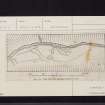
The plan of a sample area, a strip of haugh 330 ft. long on the right bank of the burn at the inflow of Pairman's Gill, shows a channel (A) which evidently once led off the burn and returned to it after a course of some 270 ft.; its lower portion is now lost in swampy vegetation but can be traced approximately by a denser growth of rushes. Its intake is now 5 ft. above the water-level, but a barrage might easily have been formed of which no trace could be expected to have survived. This channel cuts through an older and shallower one (B), which lies at a higher level and is now poorly defined, and on its lower side at this point there is a roundish pit (D), opening towards the channel by a narrow ditch. On the plan a shorter length of channel (C) and two other pits (E, F) can also be seen, the pits opening to the bank of the burn. Upstream from the planned area there are further but less definite traces of disturbance, together with the remains of what seems to have been a transverse piece of drystone walling.
Downstream, on the next stretch of haugh, an irregular ridge of spoil, broken up by pits and indentations, runs parallel with the burn for some 250 ft. with a channel on either side of it; the upper end of the landward channel curves towards the bank of the burn, as if it had once received water from it, but its bottom is at least two feet above the existing water-level.
Still farther downstream, below a small rocky gorge, a further series of pits and spoil-heaps can be seen on the left bank; these have a more recent appearance than the upper workings.
RCAHMS 1957, visited 1952 and 1953
Area centred NT 2171 2349 the remains of these workings are generally as described by RCAHMS. They are in a very mutilated and dilapidated condition.
Surveyed at 1/10,560.
Visited by OS (WDJ) 28 June 1962
Sbc Note
Visibility: This is an upstanding earthwork or monument.
Information from Scottish Borders Council

