
Pricing Change
New pricing for orders of material from this site will come into place shortly. Charges for supply of digital images, digitisation on demand, prints and licensing will be altered.
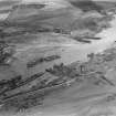
Inverkeithing, East Ness, Pier


Pier (Period Unassigned)
Site Name Inverkeithing, East Ness, Pier
Classification Pier (Period Unassigned)
Canmore ID 51023
Site Number NT18SW 96
NGR NT 1353 8219
Datum OSGB36 - NGR
Permalink http://canmore.org.uk/site/51023


- Council Fife
- Parish Inverkeithing
- Former Region Fife
- Former District Dunfermline
- Former County Fife
NT18SW 96 1353 8219
Not to be confused with Inverkeithing, West Ness, Pier (NT 1353 8202), for which see NT18SW 97. For Inverkeithing harbour (NT 131 825), see NT18SW 95.
Site recorded by Maritime Fife during the Coastal Assessment Survey for Historic Scotland, Kincardine to Fife Ness 1996

