
Pricing Change
New pricing for orders of material from this site will come into place shortly. Charges for supply of digital images, digitisation on demand, prints and licensing will be altered.
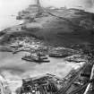
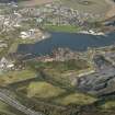
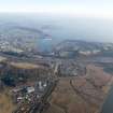
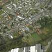
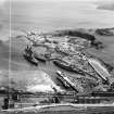
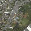
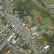
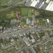
Inverkeithing, General


Burgh (Medieval), Town (Period Unassigned)
Site Name Inverkeithing, General
Classification Burgh (Medieval), Town (Period Unassigned)
Canmore ID 50999
Site Number NT18SW 75
NGR NT 1300 8200
NGR Description Centred on NT 1300 8200
Datum OSGB36 - NGR
Permalink http://canmore.org.uk/site/50999


- Council Fife
- Parish Inverkeithing
- Former Region Fife
- Former District Dunfermline
- Former County Fife
NT18SW 75 1300 8200 (Centred).
A royal burgh, first authentically appearing in charters of 1153 x 1162, Inverkeithing was granted to Robert de Londoniis before 1195. He had died childless by 1223 when the burgh was again held by the crown.
G S Pryde 1965.
In the National Library of Scotland. Vol.III. No1, of WaterColour Sketches by Thomas Brown, Advocate, is a view in Inverkeithing.
REFERNECE "Adv.MSS.34.8.1-3
Scottish Field, May 1962 p.59 - article & photographs
Photographic Survey (August 1960)
Photographs of buildings in Inverkeithing, Fife, by the Scottish National Buildings Record in August 1960.

