Pricing Change
New pricing for orders of material from this site will come into place shortly. Charges for supply of digital images, digitisation on demand, prints and licensing will be altered.
Hallyards Castle
Country House (17th Century)
Site Name Hallyards Castle
Classification Country House (17th Century)
Alternative Name(s) Castle Hallyards
Canmore ID 50785
Site Number NT17SW 7
NGR NT 1295 7329
Datum OSGB36 - NGR
Permalink http://canmore.org.uk/site/50785
- Council Edinburgh, City Of
- Parish Kirkliston (City Of Edinburgh/midlothian)
- Former Region Lothian
- Former District City Of Edinburgh
- Former County Midlothian
NT17SW 7 1295 7329.
(NT 1295 7329) Hallyards Castle (NR) (remains of)
OS 1:10000 map (1974)
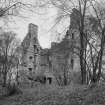
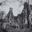
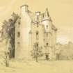
Hallyards Castle, a mid-17th century mansion, is oblong on plan, 46 1/2' N-S by 23', with a circular stair turret projecting in the middle of the E side. The date 1630 appears over one of the windows, which agrees with the style of the house, which was ruinous in 1892 and which was being affected by mining subsidence in 1913, large parts of the walls having fallen.
McCall notes a reference to Hallyards,the manor place of the barony of Liston, in 1579; it is again noted in 1619.
D MacGibbon and T Ross 1892; RCAHMS 1929, visited 1913; H B McCall 1894
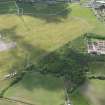
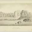
The walls of this mansion are now reduced to piles of rubble 0.3m to 1.0m high. The building is situated on a slight promontory,and has apparently been enclosed by a courtyard wall of which only the S and E sides remain. The S side exists as a bank of earth and stones c.7.0m broad and 0.8m high, while the E side appears as a low spread mound c.0.3m high on the inner side and merging with the natural slopes on the outer side. The ditch shown on the OS map round the base of the S end of the promontory is apparently a modern drainage ditch.
Surveyed at 1/2500.
Visited by (WDJ) 15 August 1961.
NMRS REFERENCE
Demolished - c.1929
Field Visit (25 June 1913)
Hallyards Castle.
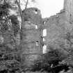
The ruin of Hallyards Castle, a mid-17th-century mansion, lies about a mile south of Kirkliston. The site has settled badly through mining, and this movement has already caused large portions of the walls to fall, while leaving others in an exceedingly dangerous state.
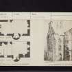
The structure is built of rubble with freestone dressings and is oblong on plan, measuring 46 ½ feet from north to south by 23 feet from east to west. Below the wall-head were four storeys, while a garret was contained within the roof. A circular stair-tower is set in the east wall with an internal as well as external projection. The entrance is placed in this tower and leads to the basement past the foot of the spacious wheel-stair which gives access to the upper floors. The entrance has a Renaissance cornice over the moulded architrave and jambs. Two moulded string-courses return across the tower, and a cavetto cornice returns along the lateral walls at wall-head level. The windows are large with back-set margins and splayed jambs. The third floor, which would be coom-ceiled, was lit by dormers placed in the lateral walls. The south-eastern angle is hollowed fora considerable height, but at some little distance below the wall-head it is corbelled out to the square.
The basement floor has been vaulted and contained a kitchen with fireplace, oven, and sink on the south, and cellars to the north. The first floor had two apartments, each having a fireplace with moulded jambs. The joists of the upper floors rested not on a scarcement or on separate corbels but on a continuous moulded corbel-course. These upper floors and the upper portion of the tower contained bedrooms. The main staircase reached to the second floor; a smaller stair led from this level to the floors above.
HISTORICAL NOTE. In 1619 there was a grant to John, Earl of Mar, of the lands of ‘Halyairdis’ with ‘the principal messuage and manor’ in the barony of Listoun (1). In 1630 the same lands with the manor were conferred in a charter of novodamus on Mr John Skene, a clerk of the College of Justice (1); and Mr Andrew Skene of Hallyards is on record in 1631 (2).
RCAHMS 1929, visited 25 June 1913.
(1) Reg. Mag. Sig. s.a. No. 2081 and No. 1566; (2) Reg. Pr. Co. iv, p . 646.


