|
Manuscripts |
MS 725/138 |
Historic Scotland Archive Project |
Report of coastal assessment survey for Historic Scotland: The Firth of Forth from Dunbar to the border of Fife. (3 volumes)
Revised version with amended text. |
1996 |
Item Level |
|
|
Manuscripts |
MS 2221/05 |
Historic Scotland Archive Project |
Survey archive: List of Vertical Aerial Photographs consulted in the NMRS, from Coastal Assessment Survey, 'The Firth of Forth from Dunbar to the Coast of Fife'. |
1996 |
Item Level |
|
 |
On-line Digital Images |
SC 1231254 |
Public Monuments and Sculpture Association (PMSA), Edinburgh Regional Archive |
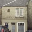
View of 2 Bell Stane, showing the 'Bell Stane' set into the wall at first floor level. |
8/10/2002 |
Item Level |
|
 |
On-line Digital Images |
SC 1231256 |
Public Monuments and Sculpture Association (PMSA), Edinburgh Regional Archive |
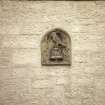
Detailed view of the 'Bell Stane' set into the wall at first floor level. |
8/10/2002 |
Item Level |
|
 |
On-line Digital Images |
SC 2440003 |
Records of the Ordnance Survey, Southampton, Hampshire, England |
South Queensferry, 1 - 2 Bell Stane, NT17NW 142, Ordnance Survey index card, Recto |
c. 1958 |
Item Level |
|
|
Manuscripts |
MS 2221/01 |
Historic Scotland Archive Project |
Survey archive: Photographic register from Coastal Assessment Survey, 'The Firth of Forth from Dunbar to the Coast of Fife'. |
1996 |
Batch Level |
|
|
Photographs and Off-line Digital Images |
BP 55/11 CN |
Historic Scotland Archive Project |
Survey photographs: Clackmannan Pow harbour, Kennetpans cottages harbour and distillery with location of enclosure, Blackness Castle with detail of 'Celtic' figure and site of St Ninian's chapel, pump and harbour at Blackness village, South Queensferry views of streets and houses. View of designed landscape at Kennetpans.
|
1996 |
Batch Level |
|
|
Photographs and Off-line Digital Images |
BS 47/11 CS |
Historic Scotland Archive Project |
Survey photographs: Alloa showing glassworks and harbour, Clackmannan Pow harbour, Kennetpans cottages harbour and distillery with location of enclosure, Blackness Castle with detail of 'Celtic' figure and site of St Ninian's chapel, pump and harbour at Blackness village, South Queensferry views of streets and houses. View of designed landscape at Kennetpans.
|
1996 |
Batch Level |
|
|
Manuscripts |
MS 2221/02 |
Historic Scotland Archive Project |
Survey archive: Record sheets from Coastal Assessment Survey, 'The Firth of Forth from Dunbar to the Coast of Fife'. |
1996 |
Batch Level |
|
|
Manuscripts |
MS 2221/03 |
Historic Scotland Archive Project |
Survey archive: Record sheets and maps of Erosion Units, from Coastal Assessment Survey, 'The Firth of Forth from Dunbar to the Coast of Fife'. |
1996 |
Batch Level |
|
|
Manuscripts |
MS 2221/04 |
Historic Scotland Archive Project |
Survey archive: Record sheets and maps of Geology and Coastal Geomorphology Units , from Coastal Assessment Survey, 'The Firth of Forth from Dunbar to the Coast of Fife'. |
1996 |
Batch Level |
|


