|
Photographs and Off-line Digital Images |
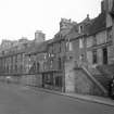
WL 3298 |
List C Survey |
General view. |
1975 |
Item Level |
|
|
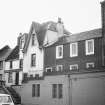
Photographs and Off-line Digital Images |
WL 3491 |
List C Survey |
General view. |
1975 |
Item Level |
|
|
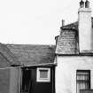
Photographs and Off-line Digital Images |
WL 3492 |
List C Survey |
General view of rear of building. |
1975 |
Item Level |
|
|
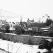
Photographs and Off-line Digital Images |
WL 807 |
Records of Ian Gordon Lindsay and Partners, architects, Edinburgh, Scotland |
South Queensferry, 1-8 East Terrace.
General view from West
|
1936 |
Item Level |
|
|
Manuscripts |
MS 725/138 |
Historic Scotland Archive Project |
Report of coastal assessment survey for Historic Scotland: The Firth of Forth from Dunbar to the border of Fife. (3 volumes)
Revised version with amended text. |
1996 |
Item Level |
|
|
Manuscripts |
MS 2221/05 |
Historic Scotland Archive Project |
Survey archive: List of Vertical Aerial Photographs consulted in the NMRS, from Coastal Assessment Survey, 'The Firth of Forth from Dunbar to the Coast of Fife'. |
1996 |
Item Level |
|
 |
On-line Digital Images |
SC 1647098 |
List C Survey |
General view. |
1975 |
Item Level |
|
 |
On-line Digital Images |
SC 1647133 |
List C Survey |
General view. |
1975 |
Item Level |
|
 |
On-line Digital Images |
SC 1647134 |
List C Survey |
General view of rear of building. |
1975 |
Item Level |
|
 |
On-line Digital Images |
SC 2439967 |
Records of the Ordnance Survey, Southampton, Hampshire, England |
South Queensferry, High Street, 7 East Terrace, NT17NW 104, Ordnance Survey index card, Recto |
1958 |
Item Level |
|
 |
On-line Digital Images |
SC 2683242 |
Records of Ian Gordon Lindsay and Partners, architects, Edinburgh, Scotland |
South Queensferry, 1-8 East Terrace.
General view from West
|
1936 |
Item Level |
|
|
Manuscripts |
MS 2221/01 |
Historic Scotland Archive Project |
Survey archive: Photographic register from Coastal Assessment Survey, 'The Firth of Forth from Dunbar to the Coast of Fife'. |
1996 |
Batch Level |
|
|
Manuscripts |
MS 2221/02 |
Historic Scotland Archive Project |
Survey archive: Record sheets from Coastal Assessment Survey, 'The Firth of Forth from Dunbar to the Coast of Fife'. |
1996 |
Batch Level |
|
|
Manuscripts |
MS 2221/03 |
Historic Scotland Archive Project |
Survey archive: Record sheets and maps of Erosion Units, from Coastal Assessment Survey, 'The Firth of Forth from Dunbar to the Coast of Fife'. |
1996 |
Batch Level |
|
|
Manuscripts |
MS 2221/04 |
Historic Scotland Archive Project |
Survey archive: Record sheets and maps of Geology and Coastal Geomorphology Units , from Coastal Assessment Survey, 'The Firth of Forth from Dunbar to the Coast of Fife'. |
1996 |
Batch Level |
|


