
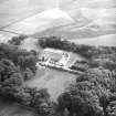
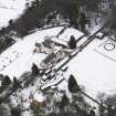
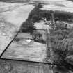
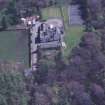
Bavelaw Castle, Outbuildings And Stables


Fortified House (17th Century)
Site Name Bavelaw Castle, Outbuildings And Stables
Classification Fortified House (17th Century)
Canmore ID 50375
Site Number NT16SE 4
NGR NT 16741 62782
Datum OSGB36 - NGR
Permalink http://canmore.org.uk/site/50375


- Council Edinburgh, City Of
- Parish Penicuik (City Of Edinburgh)
- Former Region Lothian
- Former District City Of Edinburgh
- Former County Midlothian
NT16SE 4.00 16741 62782
NT16SE 4.01 NT 1666 6277 Buildings
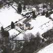
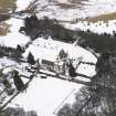
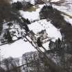
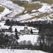
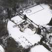
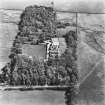
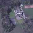
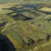
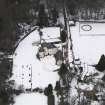
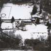
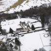
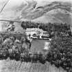
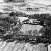
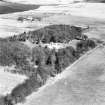
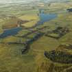
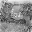
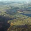
(NT 1674 6278) Bavelaw Castle (NR)
OS 6" map (1961)
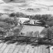
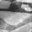
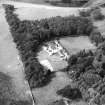
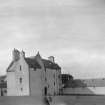
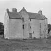
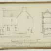
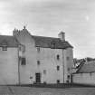
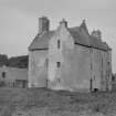
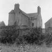
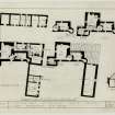
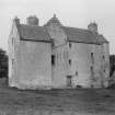
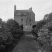
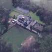
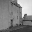
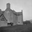
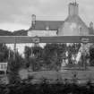
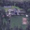
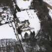
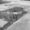
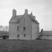
The general appearance of Bavelaw Castle, which has lately been restored indicates a date in the early 17th century, but almost certainly there is a more ancient nucleus, as witness the number and style of the gun-loops, the wall thickness, and the very small windows (N Tranter 1962). It is L-shaped, the harled rubble walls rising to three storeys and an attic. A circular tower projects at the NE angle of the main block, and another small wing extends at the SE angle; it is apparently a later construction. The ground floor is vaulted and the N vaulted chamber is at a lower level, the difference in levels being repeated above. This is probably the nucleus of the original tower, which may date from the 16th century. The N first floor chamber is known as Queen Mary's Room, the castle traditionally being a hunting seat of Queen Mary and James VI (Name Book 1852).
RCAHMS 1929, visited 1920; D MacGibbon and T Ross 1889
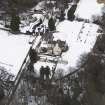
Photographed by the RCAHMS in 1980.
(Undated) information in NMRS.
BAVELAW CASTLE:
OWNER: Mr R. Douglas Miller.
ARCHITECT: Additions and alterations by Sir Robert Lorimer.
REFERENCE:
SCOTTISH NATIONAL BUILDINGS RECORD
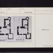
PLANS:
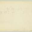
National Arts Survey - 3 sheets (T.T.S. copies 428-430)
Details of panelling in Dining Room. Elevation and details redrawn by J. Ramsay Armstrong.
(sheet includes detail of door in Midhope) - 1 sheet.
MISCELLANEOUS:
Scottish Field, August, 1995 - articles and photograph
PLANS:
Dick Peddie and MacKay, Edinburgh
Alterations J.R. MacKay, 1938
Attic 2, Bin 2, Bag 2
Photographic Survey (November 1964)
Photographic survey by the Scottish National Buildings Record/Ministry of Work in November 1964.
Archaeological Evaluation (7 October 2020 - 9 October 2020)
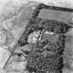
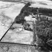
NT 16735 62792 An evaluation and Level 2 historic building survey was undertaken prior to the redevelopment of farm buildings as domestic housing.
The evaluation failed in identifying either significant archaeological features or artefacts. The building survey recorded a suite of farm buildings, predominately dating to the early 19th century, and an 18th-century bothy, formerly part of an earlier farmstead (now lost) which occupied the site.
Archive: NRHE
Funder: Private individual
John Gooder – Argyll Archaeology
(Source: DES Vol 21)

