
Hatton House, Garden Temple


Garden Temple (18th Century)
Site Name Hatton House, Garden Temple
Classification Garden Temple (18th Century)
Alternative Name(s) Grotto
Canmore ID 50363
Site Number NT16NW 5.02
NGR NT 12710 68752
Datum OSGB36 - NGR
Permalink http://canmore.org.uk/site/50363


- Council Edinburgh, City Of
- Parish Ratho
- Former Region Lothian
- Former District City Of Edinburgh
- Former County Midlothian
Hatton House, 1678 (demolished, 1955)
One of the great Renaissance houses of Scotland expanded from an original tower and later Renaissance courtyard by Lord Charles Maitland, brother of the Duke of Lauderdale. It became a great rectangular mansion, circular towers on each corner, its main tower turned into an enormous balustraded viewing platform at the centre. Its surrounding policies were equally imposing - parterres, formal gardens and wilderness - some traces of which - including the ogee-roofed pavilions at each end - remain. Most splendid survival is the magnificent winged gates.
Taken from "West Lothian: An Illustrated Architectural Guide", by Stuart Eydmann, Richard Jaques and Charles McKean, 2008. Published by the Rutland Press http://www.rias.org.uk

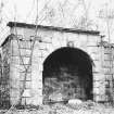
Classical garden temple, rusticated round- arch; Lauderdale arms in keystone. Twin fluted Ionic pilasters frame arch opening; datestone above 2 right pilasters; inscribed 'Anno dom MDC 1704'. Rubble walls at rear and sides. INTERIOR: segmental-vaulted roof; channelled ashlar; raised ironplate against back wall. Recessed blind windows with fluted architraves in side walls. (Historic Environment Scotland)
Hatton House was one of the great Renaissance houses of Scotland, expanded from an original tower and later Renaissance courtyard by Lord Charles Maitland. Its surrounding policies were equally imposing - parterres, formal gardens and wilderness. (R.Jacques/ C .McKean)
Hatton House was demolished in 1955, following a fire in 1952.
Photographic Survey (June 1964)
Photographic survey of the south entrance gate to Hatton House, Midlothian, and of the grotto, by the Scottish National Buildings Record/Ministry of Work in June 1964.
Project (15 September 2009)
An archaeological desk-based assessment, field recording and geophysical surveys were conducted in advance of a proposed development at Hatton House, Ratho. The assessment included a search of databases, documentary, photographic and cartographic records and a field visit. Existing structures within the study area were recorded and described. The geophysical evaluation comprised geomagnetic and electrical resistance surveys in the area of proposed new-build.
The study area covers an area of approximately 25 hectares and is bounded by fields to the north and east, a lane to the west and the A71 road to the south. The proposed development area comprises a landscaped terrace immediately south of the site of the original Hatton House and the existing bungalow.
The works were commissioned by Holmar Property Developments.
Archaeological Services Durham University. 15 September 2009. OASIS-id: archaeol3-64466
Field Visit (15 September 2009)
The garden temple or summerhouse is situated 50m west of the bungalow on the site of Hatton House (NT16NW 5.00). It is a rectangular building measuring 5m by 3m and is 3.3m high. Built of sandstone, it has a concrete-covered flat roof. The principal (south) elevation is dressed ashlar, and the side and rear walls are rubblestone. The segmental entrance arch is 2.5m wide and 2.5m high and the keystone is embossed with a Lauderdale monogram, this is an oval cartouche flanked by two large feathers, and surmounted by an earl’s coronet. The device on the cartouche is a pair of tasselled objects arranged in an inverted V, or, conceivably an opposed pair of decorative letter Ls; the exact meaning of this is unknown. Fluted Ionic pilasters frame the opening and a moulded cornice runs along the top of the wall. Inside, the room is vaulted and faced with dressed ashlar. It has 0.6m-square blind windows with fluted architraves set into the east and west walls. A 0.95m high and 0.8m wide blind window is set back into the north wall; this has been fitted with a timber frame and an iron door, but it is empty. A loose block from the façade, now inside the building, is inscribed ANNO DOM MDCCIIII (i.e. 1704); this is said to be the latest carved date at the site.
Although internally the structure appeared sound, the south-east corner of the rubble wall has suffered significant collapse. On the front elevation, several blocks are unstable, particularly those of the architectural moulding along the top. Several blocks have fallen from the front elevation at the south-east corner, and these have been moved inside. The cement covering of the roof appears to be poorly attached.
Archaeological Services Durham University, 15 September 2009. OASIS-id: archaeol3-64466

