
Following the launch of trove.scot in February 2025 we are now planning the retiral of some of our webservices. Canmore will be switched off on 24th June 2025. Information about the closure can be found on the HES website: Retiral of HES web services | Historic Environment Scotland
Currie, Kirkgate, Currie Kirk


Church (18th Century), Church (Medieval), Session House (20th Century), War Memorial(S) (20th Century)
Site Name Currie, Kirkgate, Currie Kirk
Classification Church (18th Century), Church (Medieval), Session House (20th Century), War Memorial(S) (20th Century)
Alternative Name(s) Currie Parish Church (St Kentigern's); Currie Old Parish Church; Kinleith Parish Church; War Memorial Roll Of Honour; War Memorial Panelling
Canmore ID 50274
Site Number NT16NE 18
NGR NT 18301 67655
Datum OSGB36 - NGR
Permalink http://canmore.org.uk/site/50274


- Council Edinburgh, City Of
- Parish Currie
- Former Region Lothian
- Former District City Of Edinburgh
- Former County Midlothian
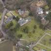
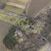
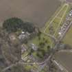
NT16NE 18.00 18301 67655
NT16NE 18.01 18318 67610 Churchyard
NT16NE 18.02 18299 67668 War Memorial
(Name: NT 18301 67655) Church (NR) (site of)
OS 1:1250 map (1973)
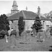
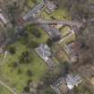
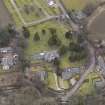
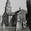
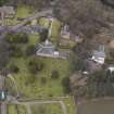
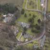
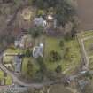
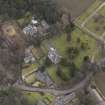
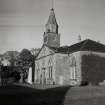
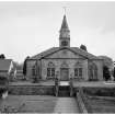
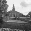
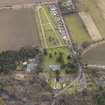
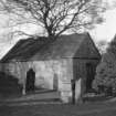
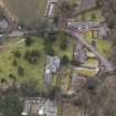
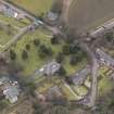
Currie, originally Kinleith, parish church, which was dedicated to St Kentigern (St Mungo) is first mentioned in 1296. The present church (at NT 1829 6764) was built in 1785; the choir of its predecessor stands some yards E, measuring 31' x 23' and standing 9' high. It has been used as a burial place, and also as the parish school. Repairs have obliterated nearly all traces of ancient work, but the exterior of the S wall shows a door and window built up, but showing pre-15th c details. Underneath the pathway W of the choir are traces of masonry, showing that the N and S walls are continued in that direction, indicative of transepts.
A Reid 1906; RCAHMS 1929, visited 1920; I B Cowan 1967; H Scott 1915; G Hay 1957
A silver ring, 1 1/8" in diameter, now in the National Museum of Antiquities of Scotland (NMAS), apparently either part of the stalk of a crucifix or of an altar candlestick, was found when digging the foundations of the present church. It is inscribed "Jesu Fili Dei miserere mei" in Saxon lettering.
Fullarton 1842
NT 1831 6764: The remains of the old church are incorporated in the David Stewart Memorial Session House of Currie Kirk, built about 1950. Practically all trace of antiquity has been obliterated but the original stonework can be seen in the lower courses of the new building, particularly in the W wall.
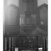
Two 13th c calvary cross-slabs, found in 1898 close to the old church are preserved in the N wall of the interior of the present church. A 13th century gravestone found at the same time now forms a window sill in the session house.
Visited by OS (JTT) 20 August 1965
The foundations of the medieval church have been exposed, and calvary crosses etc which have been found are stacked on the E side of the modern church. Built into the foundation is a large stone with early Norman detail. A bronze pin and a bronze coin or communion token were found in 1973.
Information from J Howdle, Curriehill Rd, Currie, 10 July 1973.
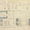
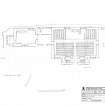
ARCHITECT: James Thompson of Leith 1784
David Bryce - reseated church 1835
David Cousin - enlarged window 1848
REFERENCE
SCOTTISH RECORD OFFICE:
Provision of a new bell for the Kirk.
Reciepted account for James Watson's proportion of its cost,
1771 GD150/3292/1/13
Building of the new kirk.
Record of payments by Charles Watson of Saughton of his proportion of the cost
1785-1786. GD150/3316/2-11
NMRS REFERENCE
PLANS: I.G.Lindsay Collection, W/37 and W/230
PRINT ROOM - Special Collections:
LOR/PRINT ROOM/38
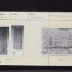
Insc: 'Currie Parish - War Memorial. Scheme for treatment of corner of Balerno, Lanark and Edinburgh Roads'
Presentation drawing, 13 3/4" x 11"
Pencil and watercolour perspective view on tracing, mounted on card.
s: Robert Lorimer
d: 8/8/1921
LOR/PRINT ROOM/31
Currie Parish Church.
Insc: 'Currie Parish Church, Lych Gate as War Memorial'
Presentation drawing, 12 1/2" x 9 1/2"
Perspective view in watercolour and pencil
s: Robert Lorimer
d: Aug.1919
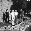
Field Visit (28 August 1920)
Parish Church, Currie.
The ruin of the choir of the old parish church of Kinleith or Currie is utilised as a burial enclosure, and stands detached some yards eastward from the present church, but within the churchyard. The structure, which is oblong on plan and is orientated measures 31 feet in length by 23 feet in breadth. The only features remaining, though barely traceable since the last repointing, are a built-up window and doorway in the south wall; these are chamfered on jambs and head. The heads are wrought from a single stone; that of the window is semicircular, while that of the doorway is three-sided. These features are not later than the 15th century. Within the enclosure are several mural tombstones, the earliest commemorating Robert Clayhills, eldest son of the laird of Innergowrie, who died in 1670. The pediment of this memorial contains the Clayhills arms, viz., parted per bend, two greyhounds courant bend-ways.*
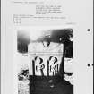
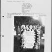
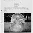
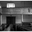
RECUMBENT SLABS. (1) Within the churchyard, about 20 feet south of the church, is a recumbent slab, 4 feet 10 inches by 1 foot 4inches by 6 ½ inches, bordered by an angle bead. At the head is a circular panel with an articulated border, containing in relief a cross-patty. Beneath the panel is incised a sword with depressed quillons and rounded pommel; on the left of the sword there appears to be a scabbard. The workmanship is crude. This slab (Fig. 85) may be related to the two following now preserved in the vestibule of the church.
(2) This stone measures 2 feet 8 inches by 11 inches by 4 inches, is back-set and contains across-head similar to (1), but the cross in this instance is canted; beneath the head a shaft is incised, very crookedly, with calvary, capital and two sur-bases. On the right of the shaft a dagger is incised, and on the left what may be a pair of shears* (Fig. 83).
(3) The other measures 2 feet 4 inches by 10 inches by 5 inches, is similarly bordered and has a cross-head similar to (1). Beneath the panels is a shaft with upper arm and calvary. On the left and linked to the shaft a pair of shears are incised* (Fig. 83).
RCAHMS 1929, visited 28 August 1920.
*Cf. Proc. Soc. Ant. Scot., xl (1905-6), p. 228.
Watching Brief (18 October 2011)
AOC archaeology group carried out a monitored topsoil strip on the site of a proposed extension to Currie Kirk. The striping of the topsoil and disturbed ground found at three burials (left in situ), and the remains of a large wall probably associated with an earlier phase of the church.
Erlend Hindmarch (AOC Archaeology Group) October 2011. OASIS-id: aocarcha1-112721

