
Lennox Tower


Tower House (Medieval)
Site Name Lennox Tower
Classification Tower House (Medieval)
Canmore ID 50270
Site Number NT16NE 14
NGR NT 17370 67125
Datum OSGB36 - NGR
Permalink http://canmore.org.uk/site/50270


- Council Edinburgh, City Of
- Parish Currie
- Former Region Lothian
- Former District City Of Edinburgh
- Former County Midlothian
NT16NE 14 17370 67125
(NT 1737 6711) Lennox Tower (NR) (Remains of)
OS 6" map (1957)
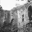
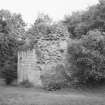
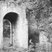
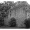
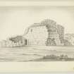
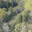
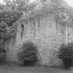
Lennox Tower dates from the 15th century. It occupies a promontory, the S end of which has been cut off by a ditch, now 6' deep, which may have had in inner rampart. The site was apparently surrounded by a barmkin, and the conformation of the ground suggests that other buildings stood between the tower and the ditch, while there are vestiges of a cross wall on the N , between the tower and the river bank. The N and W walls of the tower are 25' high, but the S and E walls are only 6' high; the ruin, in poor condition now forms a rock garden.
D MacGibbon and T Ross 1889; RCAHMS 1929, visited 1920.
Lennox Tower (name confirmed) is generally as described.
Visited by OS (JTT) 26 August 1965
Apart from the tower and ditch, there is no trace of any other features. The site is no longer a rock garden.
Surveyed at 1:1250.
Visited by OS (JTT) 26 August 1965
No change to previous field report.
Visited by OS (BS) 23 December 1975.
Field Visit (27 August 1920)
Lennox Tower.
Beside the mansion of Lymphoy, on the precipitous right bank of the Water of Leith and almost 1 of a mile above the bridge at Currie, is the ruin of Lennox Tower, a structure of considerable strength dating from the 15th century. The site is a promontory, sub-oval in form, with diameters of 60 and 70 yards, and is fronted on the north by the river and bounded on east and west by ravines, with a burn flowing through that to the west. On the south a ditch which measures 14 yards across the solum and has a depth of 6 feet, has been excavated cutting the site off in that direction; on the inner side of the ditch there may have been an intermediate rampart. Apparently the site, as might be expected, was surrounded by a wall (see HISTORICAL NOTE).
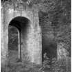
The tower stands back 20 yards from the northern bank and 7 from the eastern; the conformation of the ground suggests that between it and the ditch there once stood other buildings, while on the north between the tower and the river bank are vestiges of a cross wall. The tower is rectangular on plan, and measures 57 feet from north-east to south-west by 33 ¾ feet from north-west to south-east. The north and west walls stand in places to a height of 25 feet, but the south and east walls are nowhere higher than 6 feet. The walls have an average thickness of 8 feet at base, and are constructed with an inner and outer facing of rectangular freestone blocks in 14-inch courses. The only window now remaining has the typical 15th century chamfer on jambs and lintel. The entrance is in the north wall at ground level; it has a semicircular head. The head and jambs are rebated for an outer door opening outwards and for an inner gate of iron opening inwards, the latter secured by a bar for which a bar-hole is provided. Within this there is at present a portion of a timber bar, but this, it should be noted, is not polished by friction as are bars which are undoubted survivors. The basement floor comprised three inter communicating cellars running north and south, all ceiled with stone barrel-vaults. At the north-eastern angle of the cellar beside the entrance, a wheel-stair is formed within the thickness of the walling. The stair is 3 1/3 feet wide, and the risers are 11 ½ inches high, but are probably of modern insertion. On the first floor was a single chamber, the Hall, which had a large fireplace in the west gable and, in the north wall, a window with stone seats in the recess. In the same wall, west of the window, is a shelved aumbry rebated to receive a timber door. Above this there was at least one upper floor beneath the wall-head, which would . be surmounted by a parapet-walk.
The ruin now forms a rock garden, and while the walls have to some extent been conserved, they are not in sound condition.
SUNDIAL. On a lawn east of the mansion a 17th-century cubical angle-dial is elevated on a modern pillar. The gnomons are of iron.
HISTORICAL NOTE. According to the Statistical Account (1), this tower was ‘said to have been a habitation of the family of Lennox’, and ‘afterwards, according to the same tradition, a seat of the Regent Morton’. Further, ‘it had a subterraneous passage to the river (so that no enemy could deprive the inhabitants of water), which has been only shut up within these few years, from the cattle being apt to go down into it. The extent of the rampart, or out wall, which goes round the brow of the hill, is about 304 paces, or 1212 feet’. The place is known also as Lymphoy (2), and the lands of this name once belonged to Trinity College, Edinburgh (3).
RCAHMS 1929, visited 27 August 1920.
(1) Vol. v, p. 326 ; (2) New Stat. Acct., i, p.546; (3) See The Monros of Auchenbowie, by J. A. Inglis, pp. 176, 177, 183, for owners after 1526.

