
Pricing Change
New pricing for orders of material from this site will come into place shortly. Charges for supply of digital images, digitisation on demand, prints and licensing will be altered.
Rutherford Mains, Limekilns


Lime Kiln(S) (Post Medieval), Quarry (Post Medieval)
Site Name Rutherford Mains, Limekilns
Classification Lime Kiln(S) (Post Medieval), Quarry (Post Medieval)
Alternative Name(s) Deepsykehead Limekilns; Whitfield Lime Works
Canmore ID 50215
Site Number NT15SE 29
NGR NT 1687 5458
Datum OSGB36 - NGR
Permalink http://canmore.org.uk/site/50215


- Council Scottish Borders, The
- Parish Linton (Tweeddale)
- Former Region Borders
- Former District Tweeddale
- Former County Peebles-shire
NT15SE 29 1687 5458.
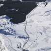
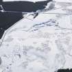
The remains of limekilns and quarry workings, identified as Whitfield Lime Works on the 2nd edition of the OS 6-inch map (Peebleshire 1900, Sheet v), have been recorded on oblique aerial photography (RCAHMSAP 2000) lying about 480m NE of Rutherford Mains.
Information from RCAHMS (KMM) 14 December 2004).
Sbc Note
Visibility: Upstanding structure, which may not be intact.
Information from Scottish Borders Council.

