
The Ord


Clearance Cairn (Period Unassigned)
Site Name The Ord
Classification Clearance Cairn (Period Unassigned)
Canmore ID 5017
Site Number NC50NE 46
NGR NC 5747 0565
Datum OSGB36 - NGR
Permalink http://canmore.org.uk/site/5017


- Council Highland
- Parish Lairg
- Former Region Highland
- Former District Sutherland
- Former County Sutherland
NC50NE 46 5747 0565
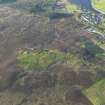
(NC 5745 0564) A burnt mound (OS [AA]) a crescentic mound of earth and boulders measuring about 42ft along the crest, about 12ft across the centre and 29ft between the points facing NE with the back to the hill.
Visited by OS (A A) 8 June 1971.
RCAHMS 1911, visited 1909.
The mound, situated high on the NE facing slope of The Ord at NC 5747 0565, is as described by the previous authorities but there was no trace of fire-reddened stone, black earth (apart from peat) or charcoal on removal of some of the stones. It displays a similar content to numerous stone clearance heaps nearby, and, together with them, delineates the edge of cultivation plots (See NC50NE 13). The only factor suggesting a burnt mound is its crescentic shape, but this is not uncommon in clearance heaps. There is no water source nearby.
Visited by OS (N K B) 26 July 1976.
Scheduled with NC50NE 13-14, 16, 17, 19, 22, 38-9, 54-6 and 81-2 as The Ord, chambered cairns, cairns, settlements and field systems.
Information from Historic Scotland, scheduling document dated 14 February 2002.
Ground Survey (22 February 2010 - 18 March 2010)
NC 575 050 A topographic survey of the scheduled area and a 100m buffer zone around the The Ord was carried out 22 February–18 March 2010. The area contains a high density of archaeological monuments, including Neolithic funerary monuments and remains of Bronze Age settlements and agriculture. Although the distribution of the major features was known, this survey added detail and increased the accuracy of information obtained in previous surveys. The survey also identified several previously unrecorded features. In total over 450 individual archaeological features were recorded including a burnt mound, c35 hut circles, 14 rectangular buildings and over 300 clearance cairns.
Archive: RCAHMS
Funder: The Forestry Commission Scotland

