
Pricing Change
New pricing for orders of material from this site will come into place shortly. Charges for supply of digital images, digitisation on demand, prints and licensing will be altered.
Back Spittal


Farm Labourers Cottage (Post Medieval), Farmstead (Post Medieval), Hospital (Period Unknown)(Possible)
Site Name Back Spittal
Classification Farm Labourers Cottage (Post Medieval), Farmstead (Post Medieval), Hospital (Period Unknown)(Possible)
Canmore ID 50164
Site Number NT15NE 25
NGR NT 1568 5738
Datum OSGB36 - NGR
Permalink http://canmore.org.uk/site/50164


- Council Midlothian
- Parish Penicuik (Midlothian)
- Former Region Lothian
- Former District Midlothian
- Former County Midlothian
NT15NE 25 1568 5738
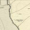
(NT 1568 5738) Back Spittal (NAT)
OS 6" map (1962)
Ruins of the Back Spittal House.
R Brown 1808
The ruins of a farmhouse (Name Book 1853), said to have been a hospital for wayfarers, and to have been associated with that at Spittal Farm (NT15NE 5) which was known as the 'Fore Spittal'. (Scott and OSA mention the hospital at Back Spittal, but locate it to the side of a stream on the N of Spittal Hill (NT 1658), giving 'Old Spittal House' as an alternative name.)
F R Coles 1899; H Scott 1950; Statistical Account (OSA) 1794
There are no indications of a hospital at the ruins of Back Spittal.
Visited by OS (WDJ) 12 February 1970
Annotated Back Spittal (Ruin of), one unroofed building is depicted on the 1st edition of the OS 6-inch map (Edinburghshire 1853-8, sheet xvii) and on the current edition of the OS 1:10560 map (1962).
Information from RCAHMS (SAH) 17 October 2000.
Field Visit (19 May 2009 - February 2011)
Measured survey by tape and offset, 19 May 2009; historical research September 2009 - February 2011.
Srp Note (28 September 2011)
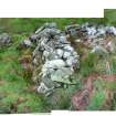
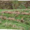
The site of Back Spittal consists of two ruined buildings situated on a secluded, sheltered, flat grassy terrace with good grazing on the N bank of the River North Esk, 1.3km W of Spittal Farm and 1.5km N of Carlops. The buildings are constructed from un-mortared water rounded boulders and their walls, which are about 1m thick, have collapsed into unconsolidated rubble mounds that still stand up to 1m high in some places but have been reduced to grass covered foundations in others.
The principal building is aligned NW – SE and measures 17m x 5.5m externally. It is divided into three inter-connected compartments, with a large unit to the SE and two smaller units to the NW. The SE unit measures 8m x 3.5m, with a possible subdivision towards the SE end and a neatly blocked gap c1m wide in the centre of the NE wall, which could have formed an entrance or window opening. The NE wall of this unit lies on a slightly different alignment from the rest of the building, suggesting at least two phases of construction. The central unit measures 2m x 3m internally and is accessed through a 0.8m wide opening in the NW wall of the SE unit, defined by very large boulders. The NW end unit is 3m square and appears to have been connected to the central unit via a gap in their shared wall. A slight depression in the NE wall may have been an external entrance. Two small semi-circular shelters have been built against the NE walls of the central and SE units, re-using stones from other parts of the building.
The second, smaller, building lies about 8m SE of the principal building, on the same alignment. It measures 8m x 5m externally, and has an opening 2m wide in the SW wall and a possible internal subdivision at the N end.
The terrace S of the buildings slopes gently but steadily down to the river, 50m below. No evidence of either rig or lazy beds was found although the land appears very suitable for cultivation, so it is possible that the area has been levelled and improved for grazing purposes.
The site does not appear in the 1841 census, although that enumerator recorded inhabited dwellings that were equally remote, and it is a ruin on the 1st Edition of the Ordnance Survey 6-inch map (Edinburghshire 1853-8, sheet xvii). The OS Namebook for the 1st Edition Survey described it as a farmhouse but explanatory notes in the Collectors Names List (p.21) make it clear that the name “Back Spittal” was assigned to this structure solely on the basis of local literary tradition because neither its name nor occupants were known to the authorities (informants: Mr R Brown of Newhall House and Peter Robb, farmer). The site must therefore have been uninhabited for some considerable time.
The steep sloping terrain surrounding the site makes access difficult and there is no obvious trackway so Back Spittal is unlikely to be a monastic Inn as the tradition suggests. However the larger structure is comparable in size and shape to 18th century sites such as Friarton NT 1710 5745 and Saltersyke NT15NE 57 (a sub-tenant’s house) both described as “cot-house” in the OS Namebook (also see Gutterford NT 15995 59392 and Thrashiedean NT12124 61054) so it could have been a small cot or sub-tenant’s house associated with either Spittal Farm or New Hall estate.
Information from SRP Pentland Hills, September 2011.

