
St Gordian's Cross


Cross Base (Early Medieval)
Site Name St Gordian's Cross
Classification Cross Base (Early Medieval)
Alternative Name(s) Font Stone, Kirkhope; Newholm Hope Burn
Canmore ID 49891
Site Number NT13SE 2
NGR NT 1941 3071
Datum OSGB36 - NGR
Permalink http://canmore.org.uk/site/49891


- Council Scottish Borders, The
- Parish Manor
- Former Region Borders
- Former District Tweeddale
- Former County Peebles-shire
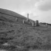
St Gordian’s Cross, Newholm Hope Burn, Kirkhope, Peeblesshire, cross-base
Measurements: H 0.48m, W 0.66m by 0.56m
Stone type: grey sandstone
Place of discovery: NT 2175 3782
Present location: in a small enclosure near Kirkhope (NT 1941 3071).
Evidence for discovery: first recorded in 1838 on a small hillock near Kirkton Manor (ID 51301), and moved about 1874 to its present location at the traditional site of St Gordian’s Chapel.
Present condition: greatly worn and damaged, especially the socket which has been enlarged to resemble a font.
Description
The stone has a waisted profile and there are hints of decoration. The rectangular base of the original socket is intact, measuring 0.23m by 0.20m.
Date: possibly tenth century.
References: RCAHMS 1967, no 379.
Compiled by A Ritchie 2016
NT13SE 2 1941 3071.
(NT 1941 3071) Font Stone on Supposed Site of St.
Gordian's Kirk (NR)
OS 6" map, Peeblesshire, 2nd ed., (1909).
Font Stone (NAT)
OS 6" map, (1963).
This stone, which has been commonly regarded as a font, is in reality a cross-base. It formerly stood at the road junction midway between Hallyards and Manor Kirk (See NT23NW 30) and now stands on a sandstone pedestal within a small enclosure. The cross-base, of grey sandstone, has been much damaged, particularly the socket which has been enlarged,apparently by battering, to form a rough basin with a notch for overflow. It is now up to 1'7" high and measures 2'2" x 1'10".
The "Coninie Stone" (NT13SE 3) was also kept here between c 1890 and 1934.
(See NT13SE 5 for St. Gordian's Kirk)
RCAHMS 1967, visited 1957.
This cross-base is as described.
Re-surveyed at 1/2500.
Visited by OS(EGC) 26 June 1961 and (BS) 4 October 1974.
Sbc Note (15 April 2016)
Visibility: Standing structure or monument.
Information from Scottish Borders Council

