
Logan Burn


Cultivation Terrace(S) (Period Unassigned)
Site Name Logan Burn
Classification Cultivation Terrace(S) (Period Unassigned)
Canmore ID 49758
Site Number NT12NW 17
NGR NT 1087 2979
NGR Description Centred NT 108 298
Datum OSGB36 - NGR
Permalink http://canmore.org.uk/site/49758


- Council Scottish Borders, The
- Parish Broughton, Glenholm And Kilbucho
- Former Region Borders
- Former District Tweeddale
- Former County Peebles-shire
NT12NW 17 centred 108 298.
(Centred NT 108 298) Cultivation Terraces (NR)
OS 6" map (1966)
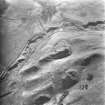
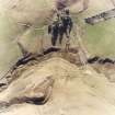
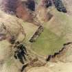
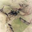
There are cultivation terraces on both banks of the Logan Burn, above and below the junction with the Dry Burn.
RCAHMS 1967, visited 1959
There are six definite, well preserved terraces in this area.
Visited by OS (WJ) 24 July 1963 and (IA) 15 September 1972.
As part of the continuing re-survey of Tweeddale the following principal sites have been recorded:
NT 1085 2987 Stone buildings - shielings.
NT 1085 2987 Cultivation terraces.
A full report has been lodged with the NMRS.
Sponsors: Biggar Museum Trust, Peeblesshire Archaeological Society.
T Ward 2000

