
Hill Of Aldie


Barrow (Prehistoric)(Possible)
Site Name Hill Of Aldie
Classification Barrow (Prehistoric)(Possible)
Alternative Name(s) Stone Circles
Canmore ID 49645
Site Number NT09NE 7
NGR NT 056 989
Datum OSGB36 - NGR
Permalink http://canmore.org.uk/site/49645


- Council Perth And Kinross
- Parish Fossoway (Perth And Kinross)
- Former Region Tayside
- Former District Perth And Kinross
- Former County Kinross-shire
NT09NE 7 056 989.
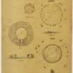
On the Hill of Aldie are the last fragments of two small circular buildings, "one of which consists of a circle of tall stones placed at regular intervals. The chamber enclosed within the circle is some 12ft in diameter.
Judging from the size of the mound there has probably been a concentric surrounding wall here." (Illustration suggests the remains of a tumulus.)
C MacLagan 1875.
Perambulation of the Hill of Aldie (Information from Mr Andrew Kerr, farmer, Middleton of Aldie), centred on NT 056 989, failed to locate either of these 'buildings'. No further information could be found locally.
Visited by OS(RD) 14 December 1967.

