
March Cairn


Chambered Cairn (Neolithic)
Site Name March Cairn
Classification Chambered Cairn (Neolithic)
Alternative Name(s) Esha Ness; Priesthoulland
Canmore ID 496
Site Number HU27NW 3
NGR HU 22168 78914
Datum OSGB36 - NGR
Permalink http://canmore.org.uk/site/496


- Council Shetland Islands
- Parish Northmavine
- Former Region Shetland Islands Area
- Former District Shetland
- Former County Shetland
HU27NW 3 2216 7891.
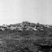
HU 221 789. The March cairn, a square cairn with a cruciform chamber, excavated by C.S.T. Calder in 1949, stands in rough pasture on a low ridge known as The Hamars of Houlland, in quite a prominent position. It now stands about 3' high.
RCAHMS 1946, visited 1936; A S Henshall 1963.
At HU 2216 7893, the March Cairn, as described and planned by Henshall. Name not known locally.
Divorced survey at 1/2500.
Visited by OS (NKB) 27 April 1969.
Field Visit (3 June 1936)
March Cairn, Hamars of Houlland, Esha Ness.
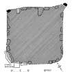
This cairn (plan, Fig. 614) which, though much ruined, is still 5 ft. 6 in. high, stands on some slightly rising ground known as the Hamars of Houlland, about half-way between the S.E. end of the Loch of Houlland and the point at which the public road passes West Hogaland. It measures 33 ft. 6 in. from N.W.to S.E. by 34 ft. 6 in. from N.E. to S.W. As will be seen from the plan, it is almost square and two corners are definitely angular, while the sides, clearly indicated by stones most of which are laid on bed, are straight. The N.E. side bears some resemblance to the facade of a heel-shaped cairn, for its extremities are marked by upright stones standing 3 ft. 5 in. and 2 ft. 7 in. high respectively. There is no sign of an entrance or passage.
RCAHMS 1946, visited 3 June 1936.
Measured Survey (3 June 1936)
RCAHMS surveyed the March Cairn on 3 June 1936 by plane-table and alidade. The resultant plan was redrawn in ink and published at a reduced size (RCAHMS 1946, fig. 605).
Excavation (1949)
The MARCH CAIRN, ESHANESS, is a construction of large stones forming a square on plan, approximately 32 feet by 32 feet, with two upright corner stones on the northern facade. Though of unusual shape it appears to be a derivative of the heel-shaped cairns judging from the character of the masonry and from the presence of a typical cruciform chamber within the structure. The chamber does not enter from the main front but from one side, where it has evidently been placed with the intention of concealment from the beginning. The chamber was floored with thin slabs raised on a seating of small boulders, but it was much reduced and had been robbed of its contents. Two tiny fragments of pottery probably represented a funerary vessel, and two small unperforated stone buttons from the rubbish of the chamber made up the total finds.
CST Calder / Society of Antiquaries of Scotland (DES 1949, 12)
Publication Account (1997)
This is a very impressive square cairn, 10m across and edged with large boulders. Taller pillar stones stand at the corners, and a large recumbent stone lies across the entrance to the tomb. The cairn has been excavated, and the amount of stones cleared off the cairn gives some idea of its original height. A short passage leads into a cruciform chamber, the east side of which is still visible. In both the passage and the chamber, a layer of small stones had been laid down as a base for a paved floor at almost the height of the recumbent stone across the entrance. Before the excavation the passage and chamber were filled with earth and stones, possibly the original filling placed there when the tomb went out of use. Two tiny sherds of pottery, two small stone discs and a quartz tool were found amongst the filling, but there was no trace of any burials.
The less well-preserved remains of another square cairn, known as Muckla Water, can be seen a short distance to the north-east. The square kerb is clearly visible, as is the chamber, but all trace of the entrance passage has gone. Both cairns command a wide view to the south.
Information from ‘Exploring Scotland’s Heritage: Shetland’, (1997).

