
Pricing Change
New pricing for orders of material from this site will come into place shortly. Charges for supply of digital images, digitisation on demand, prints and licensing will be altered.
Traigh Na H'uamhag


Monastery (Period Unassigned)(Possible)
Site Name Traigh Na H'uamhag
Classification Monastery (Period Unassigned)(Possible)
Canmore ID 4951
Site Number NC46NW 4
NGR NC 4415 6599
Datum OSGB36 - NGR
Permalink http://canmore.org.uk/site/4951


- Council Highland
- Parish Durness
- Former Region Highland
- Former District Sutherland
- Former County Sutherland
NC46NW 4 4415 6599
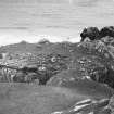
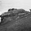
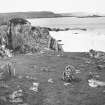
(NC 4415 6599) Over a natural arch is a causeway defended by two lines of boulders. On the promontory are two buildings - rectangular. The SW edge of the promontory may have been delimited by a wall.
Information from Dr C S Sandeman, Durness, 14 March 1967.
The promontory is approached by a natural causeway about 15ft wide over a natural arch. At the W end six boulders have been set upright in the earth. Sixteen feet to the E of the boulders the causeway is 9ft wide. On the promontory is a sub-rectangular structure, with a rectangular structure about 33ft to the E.
Information contained in letter and field notes from K Reid to OS 25 September 1978.
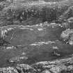
A cliff-girt promontory accessible from the landward side by a natural causeway over a natural arch. A line of earthfast angular boulders block the approach, and on the causeway itself an embedded, transverse slab may indicate a further blocking wall. On the promontory are footings of a rectangular structure measuring an estimated 8.5m by 5.0m within a wall 1.2m thick; a short distance to the E among rock outcrops are traces of a small, possibly circular structure. Along the SW side of the promontory and round the NW, stone showing in an eroded scarp indicates a skirting wall. It is unlikely that this is a fort in view of vulnerability from the NE where the cliffs give way to shelving rock. This could well be a monastic settlement and it may not be coincidental that a monastic site (NC46NW 5) is clearly viewed to the W.
Surveyed at 1:10,000.
Visited by OS (J M) 23 April 1980.
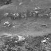
Trial Trench (30 April 2007 - 4 May 2007)
NC 4415 6599 Trial trenches were excavated from 30 April–4 May 2007 in two buildings on a promontory at Traigh na h’Uamhag, near Durness. The larger building proved to have a substantial, stone-built wall and a cobbled floor containing numerous fire-cracked stones. The smaller building had walls composed of large, upright boulders and well-built coursed masonry, with a carefully laid paved floor. The site had previously
been interpreted as a possible eremitic monastery of medieval date; however, birch charcoal from an occupation deposit in the larger building has produced a radiocarbon date of 370–100 BC at 95.4% probability (SUERC16336).
Archive to be deposited with RCAHMS. Report deposited with Highland Council SMR and RCAHMS.
Funder: Durness Development Group.

