|
Photographs and Off-line Digital Images |
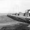
A 82114 PO |
|
View from S. |
1974 |
Item Level |
|
|
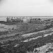
Photographs and Off-line Digital Images |
WL 834 |
|
View from SW before reconstruction. |
1966 |
Item Level |
|
 |
On-line Digital Images |
SC 451770 |
Papers of Professor John R Hume, economic and industrial historian, Glasgow, Scotland |
Blackness, Pier
View from SW, looking out to sea |
5/10/1974 |
Item Level |
|
|
Manuscripts |
MS 749/794 |
Papers of Professor John R Hume, economic and industrial historian, Glasgow, Scotland |
J R Hume Industrial/CBA cards. Filed under West Lothian county, Bo'ness and Carriden parish, Blackness Pier. Photograph noted. (See NMRS MS/749 entry for Collection description) |
|
Item Level |
|
|
Manuscripts |
MS 725/138 |
Historic Scotland Archive Project |
Report of coastal assessment survey for Historic Scotland: The Firth of Forth from Dunbar to the border of Fife. (3 volumes)
Revised version with amended text. |
1996 |
Item Level |
|
|
Manuscripts |
MS 2221/05 |
Historic Scotland Archive Project |
Survey archive: List of Vertical Aerial Photographs consulted in the NMRS, from Coastal Assessment Survey, 'The Firth of Forth from Dunbar to the Coast of Fife'. |
1996 |
Item Level |
|
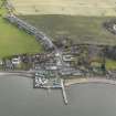 |
On-line Digital Images |
DP 075450 |
RCAHMS Aerial Photography Digital |
General oblique aerial view of Blackness village centred on the harbour, taken from the NNW. |
12/2/2010 |
Item Level |
|
 |
On-line Digital Images |
SC 1437305 |
|
View from SW before reconstruction. |
1966 |
Item Level |
|
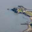 |
On-line Digital Images |
DP 250854 |
Historic Environment Scotland |
Oblique aerial view. |
27/3/2017 |
Item Level |
|
 |
On-line Digital Images |
SC 2593294 |
|
View from SW before reconstruction. |
1966 |
Item Level |
|
|
Manuscripts |
MS 2221/01 |
Historic Scotland Archive Project |
Survey archive: Photographic register from Coastal Assessment Survey, 'The Firth of Forth from Dunbar to the Coast of Fife'. |
1996 |
Batch Level |
|
|
Photographs and Off-line Digital Images |
BP 55/11 CN |
Historic Scotland Archive Project |
Survey photographs: Clackmannan Pow harbour, Kennetpans cottages harbour and distillery with location of enclosure, Blackness Castle with detail of 'Celtic' figure and site of St Ninian's chapel, pump and harbour at Blackness village, South Queensferry views of streets and houses. View of designed landscape at Kennetpans.
|
1996 |
Batch Level |
|
|
Photographs and Off-line Digital Images |
BS 47/11 CS |
Historic Scotland Archive Project |
Survey photographs: Alloa showing glassworks and harbour, Clackmannan Pow harbour, Kennetpans cottages harbour and distillery with location of enclosure, Blackness Castle with detail of 'Celtic' figure and site of St Ninian's chapel, pump and harbour at Blackness village, South Queensferry views of streets and houses. View of designed landscape at Kennetpans.
|
1996 |
Batch Level |
|
|
Manuscripts |
MS 2221/02 |
Historic Scotland Archive Project |
Survey archive: Record sheets from Coastal Assessment Survey, 'The Firth of Forth from Dunbar to the Coast of Fife'. |
1996 |
Batch Level |
|
|
Manuscripts |
MS 2221/03 |
Historic Scotland Archive Project |
Survey archive: Record sheets and maps of Erosion Units, from Coastal Assessment Survey, 'The Firth of Forth from Dunbar to the Coast of Fife'. |
1996 |
Batch Level |
|
|
Manuscripts |
MS 2221/04 |
Historic Scotland Archive Project |
Survey archive: Record sheets and maps of Geology and Coastal Geomorphology Units , from Coastal Assessment Survey, 'The Firth of Forth from Dunbar to the Coast of Fife'. |
1996 |
Batch Level |
|


