
Following the launch of trove.scot in February 2025 we are now planning the retiral of some of our webservices. Canmore will be switched off on 24th June 2025. Information about the closure can be found on the HES website: Retiral of HES web services | Historic Environment Scotland
Abercorn Castle


Castle (Medieval), Mound (Period Unassigned), Obelisk (Period Unassigned)
Site Name Abercorn Castle
Classification Castle (Medieval), Mound (Period Unassigned), Obelisk (Period Unassigned)
Alternative Name(s) Hopetoun House Policies
Canmore ID 49136
Site Number NT07NE 2
NGR NT 0828 7928
Datum OSGB36 - NGR
Permalink http://canmore.org.uk/site/49136


- Council West Lothian
- Parish Abercorn (West Lothian)
- Former Region Lothian
- Former District West Lothian
- Former County West Lothian
NT07NE 2 0828 7928
(NT 0828 7928) Abercorn Castle (NR) (site of)
OS 6" map (1967)
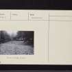
Abercorn Castle is listed as a low motte by Renn; however, its traditional site was excavated in 1963 by the Moray House Archaeological Society, and was shown to be an early 18th century mound, erected to cover ruins of two building periods.
The later structures were of a late 15th or 16th century manor house, re-using moulded stones of an earlier (medieval) date. The house had been built against an earlier wall, suitable for supporting a tower which had at some time been destroyed to the level of its footings. It may be inferred that the re-used stones had been taken from this tower-building, not earlier than the mid-15th century.
Abercorn Castle belonged to William de Avenel in the mid-12th century, later passing to the Graemes and was owned by the Douglases in 1455. On the 18th April of that year, it was captured and destroyed by James II, after a siege.
The Statistical Account (OSA) (and others), apparently in the belief that a chain of Roman forts existed between Cramond and the Antonine Wall, allege that Abercorn Castle occupies the site of a Roman fort. (No Roman finds, however, appear to have been made to support this claim).
D Renn 1968; OSA 1798; NSA 1845 (L Irving); Mr and Mrs Rae 1963
An ornamental mound as described. There is no trace of the earlier buildings nor any evidence of a Roman fort in the area.
Visited by OS (JLD) 21 January 1953 and (DWR) 28 March 1974.
The mount is depicted in 'A General Plan of Hopetoun Park', of c.1730. The accompanying key describes it as 'A Mount with a Bank and Ever Green Wilderness round From whence a Prospect of the whole River and Country as far as the Eye can serve: This Mount is formed out of the Rubbish of the Old Castle of Abercorn - Ane Obeliske on the Mount 90 feet high.'
Information from RCAHMS (IFr), 19 June 2006.
NMRS A33042/DC 45986.

