Accessibility

Font Size

100% 150% 200%

Background Colour

Default Contrast
Close Reset

Cairns Castle

Tower House (Medieval)

Site Name Cairns Castle

Classification Tower House (Medieval)

Alternative Name(s) Harperrig Reservoir; Easter Cairns

Canmore ID 49093

Site Number NT06SE 4

NGR NT 09036 60509

Datum OSGB36 - NGR

Permalink http://canmore.org.uk/site/49093

Ordnance Survey licence number AC0000807262. All rights reserved.
Canmore Disclaimer. © Bluesky International Limited 2025. Public Sector Viewing Terms

Toggle Aerial | View on large map

Digital Images

Aerial view.
Aerial view.Cairns Castle Tower and Broom Hill, oblique aerial view, taken from the NE, showing the tower in the centre of the photograph beside the house, and an area of rig and furrow cultivation in the left.Aerial view.Aerial view.Cairns Castle Tower and Broom Hill, oblique aerial view, taken from the E, showing the tower in the centre of the photograph beside the house, and an area of rig and furrow cultivation in adjacent fields.Cairns Castle Tower and Broom Hill, oblique aerial view, taken from the SW, showing the tower in the centre of the photograph beside the house, and an area of rig and furrow cultivation in the bottom half.Plan of first and ground floor of Cairns Castle.Aerial view.Cairns Castle Tower and Broom Hill, oblique aerial view, taken from the N, showing the tower in the centre of the photograph beside the house, and an area of rig and furrow cultivation in the top half.Cairns Castle Tower and Broom Hill, oblique aerial view, taken from the W, showing the tower in the centre of the photograph beside the house, and an area of rig and furrow cultivation in adjacent fields.Cairns Castle, NT06SE 4, Ordnance Survey index card, RectoCairns Castle, NT06SE 4, Ordnance Survey index card, RectoCairns Castle Tower and Broom Hill, oblique aerial view, taken from the NW, showing the tower in the centre of the photograph beside the house, and an area of rig and furrow cultivation in adjacent fields.Cairns Castle Tower and Broom Hill, oblique aerial view, taken from the WSW, showing the tower in the centre of the photograph beside the house, and an area of rig and furrow cultivation in adjacent fields.Cairns Castle Tower and Broom Hill, oblique aerial view, taken from the W, showing the tower in the centre of the photograph beside the house, and an area of rig and furrow cultivation in the bottom half.Aerial view.Aerial view.Cairns Castle, NT06SE 4, Ordnance Survey index card, page number 1, RectoAerial view.Cairns Castle Tower and Broom Hill, oblique aerial view, taken from the SSW, showing the tower in the centre of the photograph beside the house, and an area of rig and furrow cultivation in the bottom half.

Administrative Areas

  • Council West Lothian
  • Parish Mid Calder
  • Former Region Lothian
  • Former District West Lothian
  • Former County Midlothian

Recording Your Heritage Online

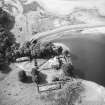
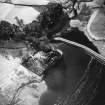
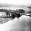
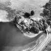
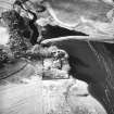
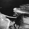
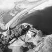
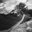
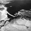
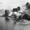
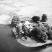
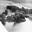
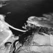
Cairns Castle, from 1440

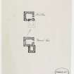
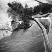
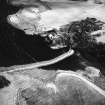
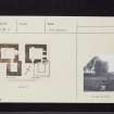
Seat of the Crichtons of Cairns, picturesquely sited on a knoll projecting into Harperrig Reservoir. Originally L-plan; a major and a minor tower with a turnpike staircase in the mutual corner. Customary cellars on the ground floor, the kitchen fireplace later turned into a principal door. Entrance tower to the east now vanished.

Taken from "West Lothian: An Illustrated Architectural Guide", by Stuart Eydmann, Richard Jaques and Charles McKean, 2008. Published by the Rutland Press http://www.rias.org.uk

Archaeology Notes

NT06SE 4 0903 6051.

(NT 0903 6051) Cairns Castle (NR) (Remains of)

OS 6" map (1957)

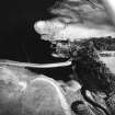
Cairns Castle, now ruinous, is of 15th century date. On plan it comprises a rectangular tower, 27 1/4' x 23 1/2'; to it is attached an 18' square wing. The walls, 4 3/4' to 6' thick, stand 30' high and show that there were at least three storeys below the wall-head. The structure is badly preserved.

RCAHMS 1929, visited 1914; H B M'Call 1894

Cairns Castle is generally as described though only the lower portion of the SW wing survives. The remains are now in a fair state of preservation.

Visited by OS (WDJ) 19 August 1965 and (JP) 6 March 1974

Architecture Notes

Non-Guardianship Sites Plan Collection.

References

MyCanmore Image Contributions


Contribute an Image

MyCanmore Text Contributions