 |
On-line Digital Images |
SC 1730112 |
Central Excavation Unit |
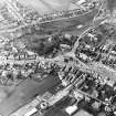
General oblique aerial view centred on the remains of the fort with the churches and churchyard adjacent, taken from the SE. |
27/2/1979 |
Item Level |
|
 |
On-line Digital Images |
SC 1730113 |
Central Excavation Unit |
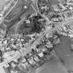
General oblique aerial view centred on the remains of the fort with the churches and churchyard adjacent, taken from the S. |
27/2/1979 |
Item Level |
|
 |
On-line Digital Images |
SC 1730114 |
Central Excavation Unit |
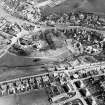
General oblique aerial view centred on the remains of the fort with the churches and churchyard adjacent, taken from the NW. |
27/2/1979 |
Item Level |
|
 |
On-line Digital Images |
SC 2436089 |
Records of the Ordnance Survey, Southampton, Hampshire, England |
Biggar, NT03NW 19, Ordnance Survey index card, page number 1, Recto |
1958 |
Item Level |
|
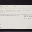 |
On-line Digital Images |
SC 2436090 |
Records of the Ordnance Survey, Southampton, Hampshire, England |
Biggar, NT03NW 19, Ordnance Survey index card, page number 2, Verso |
1958 |
Item Level |
|
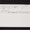 |
On-line Digital Images |
SC 2436091 |
Records of the Ordnance Survey, Southampton, Hampshire, England |
Biggar, NT03NW 19, Ordnance Survey index card, Recto |
1958 |
Item Level |
|


