
Pricing Change
New pricing for orders of material from this site will come into place shortly. Charges for supply of digital images, digitisation on demand, prints and licensing will be altered.
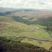
Caistel Nan Corr


Castle (Medieval)
Site Name Caistel Nan Corr
Classification Castle (Medieval)
Alternative Name(s) Castlemearn
Canmore ID 4860
Site Number NC40SE 5
NGR NC 4660 0122
Datum OSGB36 - NGR
Permalink http://canmore.org.uk/site/4860


- Council Highland
- Parish Creich (Sutherland)
- Former Region Highland
- Former District Sutherland
- Former County Sutherland
NC40SE 5 4660 0122.
(NC 46600122) Caisteal nan Corr (NR) (remains of) (NAT)
The remains of a small rectangular castle in a low-lying meadow which has been almost formed into an island by the river. The remains are fragmentary, the NW wall having entirely disappeared and the others being so ruined that no details remains, but it seems to measure about 29ft by 23 ft over walls 7 ft thick, with no trace of vaulting. It appears to have been surrounded by a ditch. Various forms of the name are given eg Castlenincorr (W Macfarlane 1906), Caisteal na Coire (Name Book 1894), Castlemearn (J Mackay 1897 and W Macfarlane 1906), or Caisteil Mearn (J Mackay 1897).
Revised at 1:2500.
RCAHMS 1911, visited 1909; J Mackay 1894; Name Book 1874; W Macfarlane 1906; Visited by OS (R D L) 25 May 1963.
The name "Caisteal nan Corr" is not widely known locally; it is generally named "The Castle". It appears to have been an unvaulted, L-shaped tower-house, so severely robbed that only the east wall, and parts of the south and north-east walls survive above ground, maximum height 2.0m, and a large part of this is obscured by tumble. The remainder of the castle forming the L-shape is visible at best as vague turf-covered footings. The overall measurements are approximately 12.0m E to W by 11.0m N to S, the re-entrant angle being to the NE. The castle stands on a platform, raised about 0.3m above the surrounding flood-plain, and is bounded by a system of modern drainage ditches and wet depressions; some of these ditches may have incorporated a moat.
Visited by OS (N K B) 1 November 1976.
Examination of the site revealed that the S wall has the fragmentary remains of a scarcement. Part of a sandstone rotary quern used as a "rubber", was found in the rubble. Retained by writer.
J E Kirby 1976.
Field Visit (30 June 1909)
48. Caisteal na coire. Some 2/3 m. SW. of Rosehall, in a low-lying meadow, almost formed into an island by the River Oykell and a creek which runs W. from the river for about ¼ m., are the fragmentary ruins of a small rectangular building. The NW. wall has entirely disappeared, the other walls are much ruined, and no details of the structure remain. The exterior measurements appear to have been about 29' x 23', and the thickness of the walls 7'. There is no sign of vaulting. The castle seems to have been encircled by a ditch.
OS 6-inch map: Sutherland Sheet ci.
RCAHMS 1911, visited (AOC) 30th June 1909.
Field Visit (1996 - 2003)
Russell Coleman managed an Historic Scotland funded project to record medieval moated sites in Scotland. Gazetteers were produced for each regional council area between 1996 and 2002 with an uncompleted overall review in 2002-03. The results of the first year of the project were published in Tayside and Fife Archaeological Journal, Volume 3 (1997).

