
Pricing Change
New pricing for orders of material from this site will come into place shortly. Charges for supply of digital images, digitisation on demand, prints and licensing will be altered.
Skirling Castle


Castle (Medieval)
Site Name Skirling Castle
Classification Castle (Medieval)
Canmore ID 48585
Site Number NT03NE 10
NGR NT 0728 3894
Datum OSGB36 - NGR
Permalink http://canmore.org.uk/site/48585


- Council Scottish Borders, The
- Parish Skirling
- Former Region Borders
- Former District Tweeddale
- Former County Peebles-shire
NT03NE 10 0728 3894.
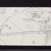
(NT 0728 3894) Skirling Castle (NR) (Site of)
OS 6" map, (1957).
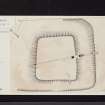
Skirling Castle (Site): The remains have been under the plough and are now very scanty. They comprise a low rectangular mound surrounded by a shallow ditch. The summit of the mound measures about 140' NE -SW by about 130'; fragments of stone and lime mortar can be seen here and there upon the surface. The SW and SE sectors of the ditch are the best preserved, the bottom here varying in width from 15' to 30'; in the centre of the SW sector the bottom of the ditch expands abruptly to a width of 28'. The NW and NE sectors of the ditch are represented by an ill-defined area of marshy ground.
Documentary evidence associates this site with a residence of the Cockburns, proprietors of the barony of Skirling from the late 14th to the early 17th century.
Writing in about 1792, the author of the Statistical Account (OSA) says "The house of Skirling appears, by the vestiges of the walls, to have been large. It was surrounded by a morass or bog, except a small space on the SW side, and that was defended by turrets. The entry to the house was by a bridge of stone over this bog." If this bridge was on the SW side, its site may now be represented by the expansion of the ditch in the center of this sector. An account of the castle written in about 1860 states that "all that now remains to mark its site is a small mound and the faint traces of what appears to have been a moat surrounding the castle": these features are indicated on the first edition of the O S 6" map, but have been omitted on later editions.
Small-scale excavations carried out by the Commission in 1962-3 confirmed that the site is of a late medieval castle, and the finds indicated a continuous period of occupation from the second half of the 15th century to about the end of the 16th century. On its SE side the castle was found to have been defended by an upcast bank, a wet ditch about 30' in width and 4' in depth, and by what were probably outer and inner enclosure-walls measuring about 4'6" and 7' in thickness respectively. Traces of what may have been a single enclosure-wall were found on the outer NW perimeter of the mound. No remains of any structure were encountered upon the summit of the mound, and it seems probable that all the internal buildings of the castle were thoroughly dismantled and their traces subsequently obliterated the plough. No evidence was found of any earlier occupation of the site.
RCAHMS 1967, visited 1963.
The castle mound has been mutilated by ploughing, and only on the SE are there clear indications of the ditch.
Surveyed at 1:2500.
Visited by OS(DWR) 8 September 1972.
Excavation (1962 - 1963)
Small-scale excavations carried out by the Commission in 1962-3 confirmed that the site is of a late medieval castle, and the finds indicated a continuous period of occupation from the second half of the 15th century to about the end of the 16th century. On its SE side the castle was found to have been defended by an upcast bank, a wet ditch about 30' in width and 4' in depth, and by what were probably outer and inner enclosure-walls measuring about 4'6" and 7' in thickness respectively. Traces of what may have been a single enclosure-wall were found on the outer NW perimeter of the mound. No remains of any structure were encountered upon the summit of the mound, and it seems probable that all the internal buildings of the castle were thoroughly dismantled and their traces subsequently obliterated the plough. No evidence was found of any earlier occupation of the site.
RCAHMS 1967
Sbc Note
Visibility: This site has been excavated.
Information from Scottish Borders Council

